Villahermosa elevation
Villahermosa (Tolima), Colombia elevation is 2046 meters and Villahermosa elevation in feet is 6713 ft above sea level [src 1]. Villahermosa is a seat of a second-order administrative division (feature code) with elevation that is 897 meters (2943 ft) bigger than average city elevation in Colombia.
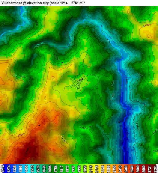
Below is the Elevation map of Villahermosa, which displays elevation range with different colors. Scale of the first map is from 1214 to 2781 m (3983 to 9124 ft) with average elevation of 1891.5 meters (=6206 ft) [note 1]
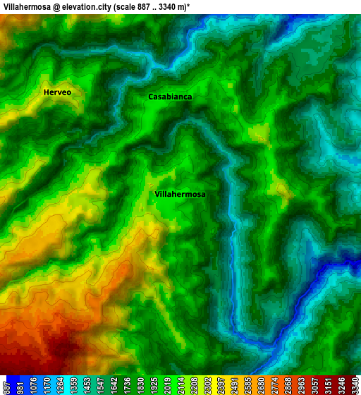
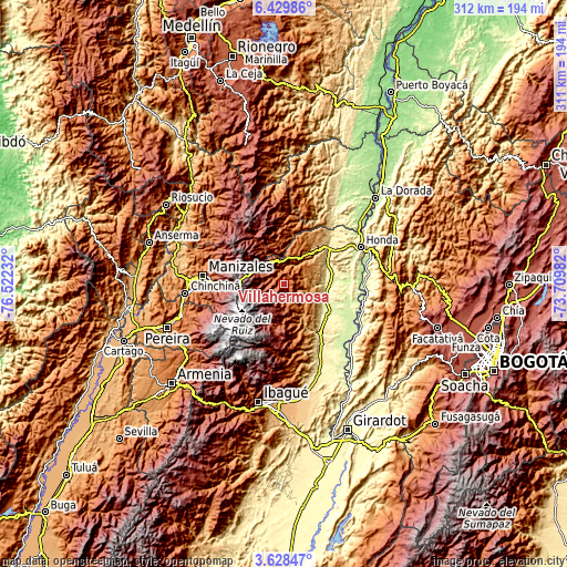
These maps also provides idea of topography and contour of this city, they are displayed at different zoom levels. More info about maps, scale and edge coordinates you can find below images.
| \ | Map #1 | Map #2 | Topo.Map |
| Scale [m] | 1214..2781 m | 887..3340 m | × |
| Scale [ft] | 3983..9124 ft | 2910..10958 ft | × |
| Average | 1891.5 m = 6206 ft | 1872.2 m = 6142 ft | × |
| Width | 9.73 km = 6 mi | 19.47 km = 12.1 mi | 311.5 km = 193.6 mi |
| Height | 9.73 km = 6 mi | 19.47 km = 12.1 mi | 311.5 km = 193.6 mi |
| ↑Max Latitude | 5.074445° | 5.118216° | 6.42986° |
| Latitude at center | 5.03067° | 5.03067° | 5.03067° |
| ↓Min Latitude | 4.986893° | 4.943112° | 3.62847° |
| ← Min Longitude | -75.160015° | -75.203961° | -76.52232° |
| Longitude center | -75.11607° | -75.11607° | -75.11607° |
| →Max Longitude | -75.072125° | -75.028179° | -73.70982° |
Nearby cities:
Cities around Villahermosa sort by population:
• Líbano elevation 1575 m
13.5 km,  153°
153°
• Padua 2041 m
11.8 km,  347°
347°
• Fresno 1467 m
16.2 km,  33°
33°
• Manzanares 2224 m
25.2 km, 350°
• Armero-Guyabal 341 m
24.6 km,  106°
106°
• Guayabal 280 m
25.4 km,  89°
89°
• Falan 954 m
20.9 km,  60°
60°
• Palocabildo 1451 m
14.6 km,  48°
48°
• Herveo 1976 m
8.6 km,  309°
309°
• Murillo 2986 m
18.5 km,  199°
199°
• Casabianca 2036 m
5.5 km, 354°
• Frías 1321 m
11.9 km, 90°
Multilingual:
 En español:
Villahermosa elevación 2046 m.
 En France:
Villahermosa élévation 2046 m.
 Auf Deutsch:
Villahermosa höhe über dem Meeresspiegel ist 2046 m.

Sources and notes:
- [note 1] Map square and city borders are not equal. Map elevation data is calculated only from area inside that square.
- [src 1] Elevation data from geonames database provided with same terms of usage.
- [src 2] The elevation map of Villahermosa is generated using elevation data from NASA's 3 arcsec (90m) resolution SRTM data.
- [src 3] Base (background) map © OpenStreetMap contributors tiles are generated by Geofabrik and OpenTopoMap.
Copyright & License:
This Villahermosa Elevation Map is licensed under CC BY-SA. You may reuse any part from this page, if you give a proper credit by linking to this URL:
 More info on terms of use page.