Murillo elevation
Murillo (Tolima), Colombia elevation is 2986 meters and Murillo elevation in feet is 9797 ft above sea level [src 1]. Murillo is a seat of a second-order administrative division (feature code) with elevation that is 1837 meters (6027 ft) bigger than average city elevation in Colombia.
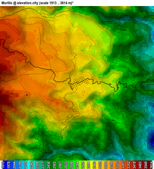
Below is the Elevation map of Murillo, which displays elevation range with different colors. Scale of the first map is from 1913 to 3614 m (6276 to 11857 ft) with average elevation of 2813.7 meters (=9231 ft) [note 1]
These maps also provides idea of topography and contour of this city, they are displayed at different zoom levels. More info about maps, scale and edge coordinates you can find below images.
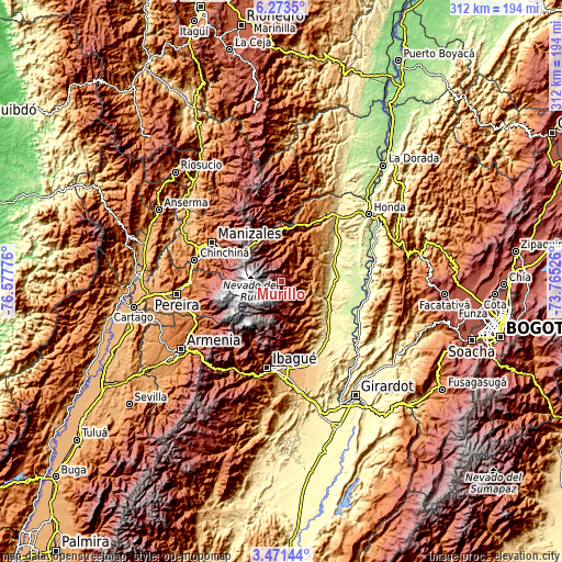
| \ | Map #1 | Topo.Map |
| Scale [m] | 1913..3614 m | × |
| Scale [ft] | 6276..11857 ft | × |
| Average | 2813.7 m = 9231 ft | × |
| Width | 9.74 km = 6.1 mi | 311.6 km = 193.6 mi |
| Height | 9.74 km = 6.1 mi | 311.6 km = 193.6 mi |
| ↑Max Latitude | 4.917715° | 6.2735° |
| Latitude at center | 4.87393° | 4.87393° |
| ↓Min Latitude | 4.830142° | 3.47144° |
| ← Min Longitude | -75.215455° | -76.57776° |
| Longitude center | -75.17151° | -75.17151° |
| →Max Longitude | -75.127565° | -73.76526° |
Nearby cities:
Cities around Murillo sort by population:
• Líbano elevation 1575 m
13.2 km,  66°
66°
• Lérida 345 m
29 km,  92°
92°
• Padua 2041 m
29.2 km,  6°
6°
• Armero-Guyabal 341 m
31.5 km, 70°
• Venadillo 334 m
31.9 km,  122°
122°
• Junín 1235 m
19.9 km, 120°
• Villahermosa 2046 m
18.5 km,  19°
19°
• Herveo 1976 m
22.9 km,  358°
358°
• Anzoátegui 1767 m
28.3 km,  162°
162°
• Casabianca 2036 m
23.6 km, 13°
• Frías 1321 m
25 km,  46°
46°
• Santa Isabel 2277 m
19.5 km, 155°
Multilingual:
 En español:
Murillo elevación 2986 m.
 En France:
Murillo élévation 2986 m.
 Auf Deutsch:
Murillo höhe über dem Meeresspiegel ist 2986 m.

Sources and notes:
- [note 1] Map square and city borders are not equal. Map elevation data is calculated only from area inside that square.
- [src 1] Elevation data from geonames database provided with same terms of usage.
- [src 2] The elevation map of Murillo is generated using elevation data from NASA's 3 arcsec (90m) resolution SRTM data.
- [src 3] Base (background) map © OpenStreetMap contributors tiles are generated by Geofabrik and OpenTopoMap.
Copyright & License:
This Murillo Elevation Map is licensed under CC BY-SA. You may reuse any part from this page, if you give a proper credit by linking to this URL:
 More info on terms of use page.