Junín elevation
Junín (Tolima, Venadillo), Colombia elevation is 1235 meters and Junín elevation in feet is 4052 ft above sea level [src 1]. Junín is a populated place (feature code) with elevation that is 86 meters (282 ft) bigger than average city elevation in Colombia.
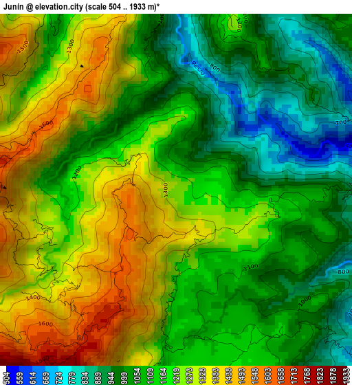
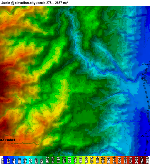
Below is the Elevation map of Junín, which displays elevation range with different colors. Scale of the first map is from 504 to 1933 m (1654 to 6342 ft) with average elevation of 1169 meters (=3835 ft) [note 1]
These maps also provides idea of topography and contour of this city, they are displayed at different zoom levels. More info about maps, scale and edge coordinates you can find below images.
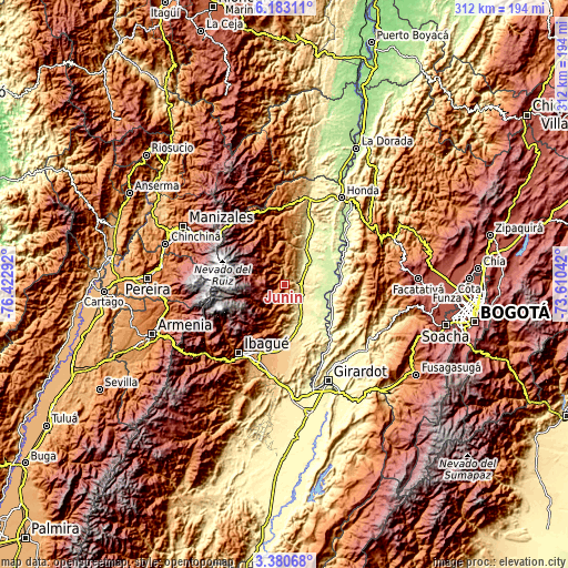
| \ | Map #1 | Map #2 | Topo.Map |
| Scale [m] | 504..1933 m | 278..2667 m | × |
| Scale [ft] | 1654..6342 ft | 912..8750 ft | × |
| Average | 1169 m = 3835 ft | 1185.9 m = 3891 ft | × |
| Width | 9.74 km = 6.1 mi | 19.48 km = 12.1 mi | 311.6 km = 193.6 mi |
| Height | 9.74 km = 6.1 mi | 19.48 km = 12.1 mi | 311.6 km = 193.6 mi |
| ↑Max Latitude | 4.827121° | 4.870909° | 6.18311° |
| Latitude at center | 4.78333° | 4.78333° | 4.78333° |
| ↓Min Latitude | 4.739536° | 4.69574° | 3.38068° |
| ← Min Longitude | -75.060615° | -75.104561° | -76.42292° |
| Longitude center | -75.01667° | -75.01667° | -75.01667° |
| →Max Longitude | -74.972725° | -74.928779° | -73.61042° |
Nearby cities:
Cities around Junín sort by population:
• Líbano elevation 1575 m
16.2 km,  341°
341°
• Lérida 345 m
14.8 km,  53°
53°
• Armero-Guyabal 341 m
24 km,  31°
31°
• Venadillo 334 m
12 km,  126°
126°
• Ambalema 231 m
28.1 km,  89°
89°
• Villahermosa 2046 m
29.6 km, 338°
• Anzoátegui 1767 m
19 km,  206°
206°
• Alvarado 412 m
25 km,  163°
163°
• Murillo 2986 m
19.9 km,  300°
300°
• Frías 1321 m
27.4 km,  1°
1°
• Beltrán 231 m
30.5 km, 86°
• Santa Isabel 2277 m
11.8 km,  229°
229°
Multilingual:
 En español:
Junín elevación 1235 m.
 En France:
Junín élévation 1235 m.


Sources and notes:
- [note 1] Map square and city borders are not equal. Map elevation data is calculated only from area inside that square.
- [src 1] Elevation data from geonames database provided with same terms of usage.
- [src 2] The elevation map of Junín is generated using elevation data from NASA's 3 arcsec (90m) resolution SRTM data.
- [src 3] Base (background) map © OpenStreetMap contributors tiles are generated by Geofabrik and OpenTopoMap.
Copyright & License:
This Junín Elevation Map is licensed under CC BY-SA. You may reuse any part from this page, if you give a proper credit by linking to this URL:
 More info on terms of use page.