Ulashan elevation
Ulashan (Inner Mongolia), China elevation is 1021 meters and Ulashan elevation in feet is 3350 ft above sea level [src 1]. Ulashan is a seat of a third-order administrative division (feature code) with elevation that is 463 meters (1519 ft) bigger than average city elevation in China.
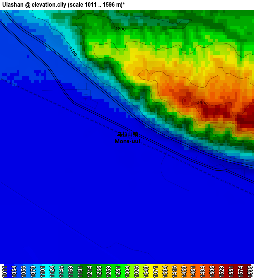
Below is the Elevation map of Ulashan, which displays elevation range with different colors. Scale of the first map is from 1011 to 1596 m (3317 to 5236 ft) with average elevation of 1113.8 meters (=3654 ft) [note 1]
These maps also provides idea of topography and contour of this city, they are displayed at different zoom levels. More info about maps, scale and edge coordinates you can find below images.
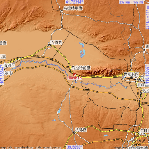
| \ | Map #1 | Topo.Map |
| Scale [m] | 1011..1596 m | × |
| Scale [ft] | 3317..5236 ft | × |
| Average | 1113.8 m = 3654 ft | × |
| Width | 7.41 km = 4.6 mi | 237.2 km = 147.4 mi |
| Height | 7.41 km = 4.6 mi | 237.2 km = 147.4 mi |
| ↑Max Latitude | 40.698326° | 41.72314° |
| Latitude at center | 40.665° | 40.665° |
| ↓Min Latitude | 40.631658° | 39.5898° |
| ← Min Longitude | 108.700775° | 107.33847° |
| Longitude center | 108.74472° | 108.74472° |
| →Max Longitude | 108.788665° | 110.15097° |
Nearby cities:
Cities around Ulashan sort by population:
• Ordos elevation 1310 m
146.8 km,  143°
143°
• Bayan Nur 1050 m
114.8 km,  274°
274°
• Baotou 1066 m
90.9 km,  90°
90°
• Dongsheng 1439 m
140.9 km,  132°
132°
• Shiguai 1337 m
130 km, 87°
• Aletengxire 1304 m
148.3 km, 144°
• Tianjiao 1440 m
141.6 km, 131°
• Xamba 1038 m
137.3 km,  280°
280°
• Jinshan 1347 m
117.3 km,  69°
69°
• Shulinzhao 1011 m
112.5 km,  105°
105°
• Haliut 1265 m
100.9 km,  349°
349°
• Xinli 1362 m
91.3 km,  180°
180°
Multilingual:
 En español:
Ulashan elevación 1021 m.
 En France:
Ulashan élévation 1021 m.
 Auf Deutsch:
Ulashan höhe über dem Meeresspiegel ist 1021 m.

Sources and notes:
- [note 1] Map square and city borders are not equal. Map elevation data is calculated only from area inside that square.
- [src 1] Elevation data from geonames database provided with same terms of usage.
- [src 2] The elevation map of Ulashan is generated using elevation data from NASA's 3 arcsec (90m) resolution SRTM data.
- [src 3] Base (background) map © OpenStreetMap contributors tiles are generated by Geofabrik and OpenTopoMap.
Copyright & License:
This Ulashan Elevation Map is licensed under CC BY-SA. You may reuse any part from this page, if you give a proper credit by linking to this URL:
 More info on terms of use page.