Baotou elevation
Baotou (Inner Mongolia), China elevation is 1066 meters and Baotou elevation in feet is 3497 ft above sea level [src 1]. Baotou is a populated place (feature code) with elevation that is 508 meters (1667 ft) bigger than average city elevation in China.
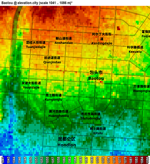
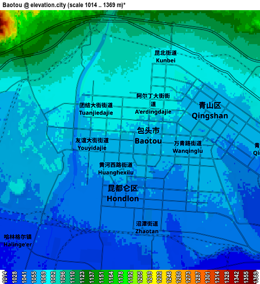
Below is the Elevation map of Baotou, which displays elevation range with different colors. Scale of the first map is from 1041 to 1086 m (3415 to 3563 ft) with average elevation of 1063.1 meters (=3488 ft) [note 1]
These maps also provides idea of topography and contour of this city, they are displayed at different zoom levels. More info about maps, scale and edge coordinates you can find below images.
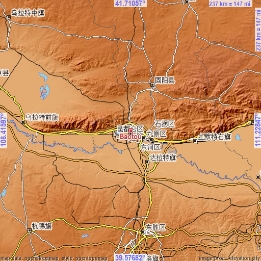
| \ | Map #1 | Map #2 | Topo.Map |
| Scale [m] | 1041..1086 m | 1014..1369 m | × |
| Scale [ft] | 3415..3563 ft | 3327..4491 ft | × |
| Average | 1063.1 m = 3488 ft | 1069.1 m = 3508 ft | × |
| Width | 7.41 km = 4.6 mi | 14.83 km = 9.2 mi | 237.3 km = 147.5 mi |
| Height | 7.41 km = 4.6 mi | 14.83 km = 9.2 mi | 237.2 km = 147.4 mi |
| ↑Max Latitude | 40.685552° | 40.718867° | 41.71057° |
| Latitude at center | 40.65222° | 40.65222° | 40.65222° |
| ↓Min Latitude | 40.618871° | 40.585506° | 39.57682° |
| ← Min Longitude | 109.778275° | 109.734329° | 108.41597° |
| Longitude center | 109.82222° | 109.82222° | 109.82222° |
| →Max Longitude | 109.866165° | 109.910111° | 111.22847° |
Nearby cities:
Cities around Baotou sort by population:
• Ordos elevation 1310 m
116.1 km,  181°
181°
• Dongsheng 1439 m
93.9 km,  171°
171°
• Shiguai 1337 m
39.5 km,  81°
81°
• Salaqi 1000 m
59.4 km,  101°
101°
• Bailingmiao 1385 m
126.5 km,  23°
23°
• Tongyangdao 1603 m
124.9 km,  5°
5°
• Aletengxire 1304 m
119.4 km, 182°
• Qasq 1026 m
110.4 km,  86°
86°
• Tianjiao 1440 m
93.1 km, 170°
• Ulashan 1021 m
90.9 km,  270°
270°
• Jinshan 1347 m
46.6 km, 24°
• Shulinzhao 1011 m
33.6 km,  149°
149°
Multilingual:
 En español:
Baotou elevación 1066 m.
 En France:
Baotou élévation 1066 m.


Sources and notes:
- [note 1] Map square and city borders are not equal. Map elevation data is calculated only from area inside that square.
- [src 1] Elevation data from geonames database provided with same terms of usage.
- [src 2] The elevation map of Baotou is generated using elevation data from NASA's 3 arcsec (90m) resolution SRTM data.
- [src 3] Base (background) map © OpenStreetMap contributors tiles are generated by Geofabrik and OpenTopoMap.
Copyright & License:
This Baotou Elevation Map is licensed under CC BY-SA. You may reuse any part from this page, if you give a proper credit by linking to this URL:
 More info on terms of use page.