Bayan Nur elevation
Bayan Nur (Inner Mongolia), China elevation is 1050 meters and Bayan Nur elevation in feet is 3445 ft above sea level [src 1]. Bayan Nur is a populated place (feature code) with elevation that is 492 meters (1614 ft) bigger than average city elevation in China.
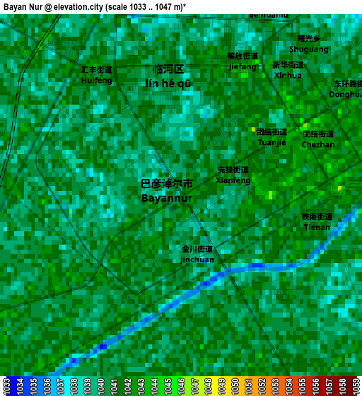
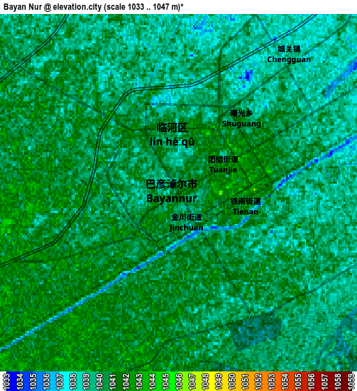
Below is the Elevation map of Bayan Nur, which displays elevation range with different colors. Scale of the first map is from 1033 to 1047 m (3389 to 3435 ft) with average elevation of 1040.2 meters (=3413 ft) [note 1]
These maps also provides idea of topography and contour of this city, they are displayed at different zoom levels. More info about maps, scale and edge coordinates you can find below images.
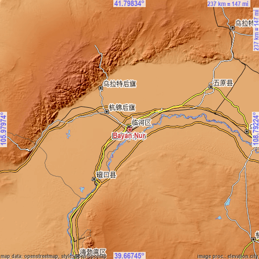
| \ | Map #1 | Map #2 | Topo.Map |
| Scale [m] | 1033..1047 m | 1033..1047 m | × |
| Scale [ft] | 3389..3435 ft | 3389..3435 ft | × |
| Average | 1040.2 m = 3413 ft | 1039.8 m = 3411 ft | × |
| Width | 7.4 km = 4.6 mi | 14.81 km = 9.2 mi | 236.9 km = 147.2 mi |
| Height | 7.4 km = 4.6 mi | 14.81 km = 9.2 mi | 236.9 km = 147.2 mi |
| ↑Max Latitude | 40.774717° | 40.807988° | 41.79834° |
| Latitude at center | 40.74143° | 40.74143° | 40.74143° |
| ↓Min Latitude | 40.708126° | 40.674805° | 39.66745° |
| ← Min Longitude | 107.342045° | 107.298099° | 105.97974° |
| Longitude center | 107.38599° | 107.38599° | 107.38599° |
| →Max Longitude | 107.429935° | 107.473881° | 108.79224° |
Nearby cities:
Cities around Bayan Nur sort by population:
• Wuhai elevation 1096 m
127.1 km,  202°
202°
• Shizuishan 1103 m
175.7 km, 197°
• Wuda 1129 m
149.5 km, 202°
• Shitanjing 1428 m
189.6 km,  207°
207°
• Beijie 1094 m
176.9 km, 197°
• Xinli 1362 m
151.8 km,  131°
131°
• Bayinsai 1120 m
149.2 km, 202°
• Haliut 1265 m
131.2 km,  46°
46°
• Ulashan 1021 m
114.8 km,  94°
94°
• Bayan Gol 1053 m
59.7 km, 214°
• Bayinbaolige 1035 m
47.3 km,  325°
325°
• Xamba 1038 m
26.1 km,  307°
307°
Multilingual:
 En español:
Bayan Nur elevación 1050 m.
 En France:
Bayan Nur élévation 1050 m.
 Auf Deutsch:
Bayan Nur höhe über dem Meeresspiegel ist 1050 m.

Sources and notes:
- [note 1] Map square and city borders are not equal. Map elevation data is calculated only from area inside that square.
- [src 1] Elevation data from geonames database provided with same terms of usage.
- [src 2] The elevation map of Bayan Nur is generated using elevation data from NASA's 3 arcsec (90m) resolution SRTM data.
- [src 3] Base (background) map © OpenStreetMap contributors tiles are generated by Geofabrik and OpenTopoMap.
Copyright & License:
This Bayan Nur Elevation Map is licensed under CC BY-SA. You may reuse any part from this page, if you give a proper credit by linking to this URL:
 More info on terms of use page.