Wuhai elevation
Wuhai (Inner Mongolia), China elevation is 1096 meters and Wuhai elevation in feet is 3596 ft above sea level [src 1]. Wuhai is a seat of a second-order administrative division (feature code) with elevation that is 538 meters (1765 ft) bigger than average city elevation in China.
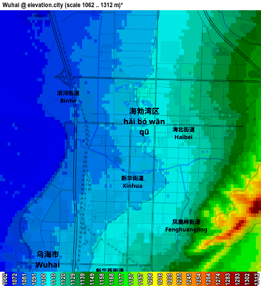
Below is the Elevation map of Wuhai, which displays elevation range with different colors. Scale of the first map is from 1062 to 1312 m (3484 to 4304 ft) with average elevation of 1107.2 meters (=3633 ft) [note 1]
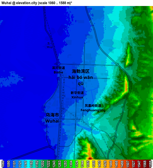
These maps also provides idea of topography and contour of this city, they are displayed at different zoom levels. More info about maps, scale and edge coordinates you can find below images.
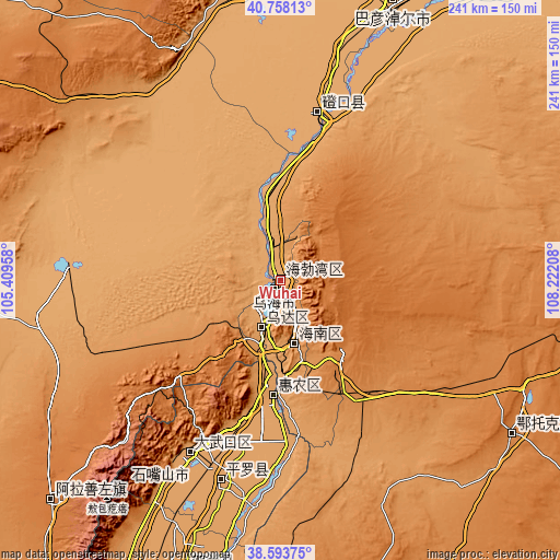
| \ | Map #1 | Map #2 | Topo.Map |
| Scale [m] | 1062..1312 m | 1060..1588 m | × |
| Scale [ft] | 3484..4304 ft | 3478..5210 ft | × |
| Average | 1107.2 m = 3633 ft | 1133.6 m = 3719 ft | × |
| Width | 7.52 km = 4.7 mi | 15.04 km = 9.3 mi | 240.7 km = 149.6 mi |
| Height | 7.52 km = 4.7 mi | 15.04 km = 9.3 mi | 240.7 km = 149.6 mi |
| ↑Max Latitude | 39.718231° | 39.752025° | 40.75813° |
| Latitude at center | 39.68442° | 39.68442° | 39.68442° |
| ↓Min Latitude | 39.650593° | 39.616749° | 38.59375° |
| ← Min Longitude | 106.771885° | 106.727939° | 105.40958° |
| Longitude center | 106.81583° | 106.81583° | 106.81583° |
| →Max Longitude | 106.859775° | 106.903721° | 108.22208° |
Nearby cities:
Cities around Wuhai sort by population:
• Bayan Nur elevation 1050 m
127.1 km,  22°
22°
• Shizuishan 1103 m
50.3 km,  184°
184°
• Dawukou 1119 m
80 km,  206°
206°
• Wuda 1129 m
22.4 km,  203°
203°
• Shitanjing 1428 m
64.4 km,  218°
218°
• Xamba 1038 m
136.3 km,  11°
11°
• Xigang 1111 m
132.2 km, 197°
• Ulan 1375 m
119.7 km,  123°
123°
• Pingluo Chengguanzhen 1102 m
90 km, 195°
• Bayan Gol 1053 m
69.9 km, 11°
• Beijie 1094 m
51.5 km, 184°
• Bayinsai 1120 m
22.1 km, 201°
Multilingual:
 En español:
Wuhai elevación 1096 m.
 En France:
Wuhai élévation 1096 m.


Sources and notes:
- [note 1] Map square and city borders are not equal. Map elevation data is calculated only from area inside that square.
- [src 1] Elevation data from geonames database provided with same terms of usage.
- [src 2] The elevation map of Wuhai is generated using elevation data from NASA's 3 arcsec (90m) resolution SRTM data.
- [src 3] Base (background) map © OpenStreetMap contributors tiles are generated by Geofabrik and OpenTopoMap.
Copyright & License:
This Wuhai Elevation Map is licensed under CC BY-SA. You may reuse any part from this page, if you give a proper credit by linking to this URL:
 More info on terms of use page.