Baiquan elevation
Baiquan (Jilin), China elevation is 336 meters and Baiquan elevation in feet is 1102 ft above sea level [src 1]. Baiquan is a seat of a third-order administrative division (feature code) with elevation that is 222 meters (728 ft) smaller than average city elevation in China.
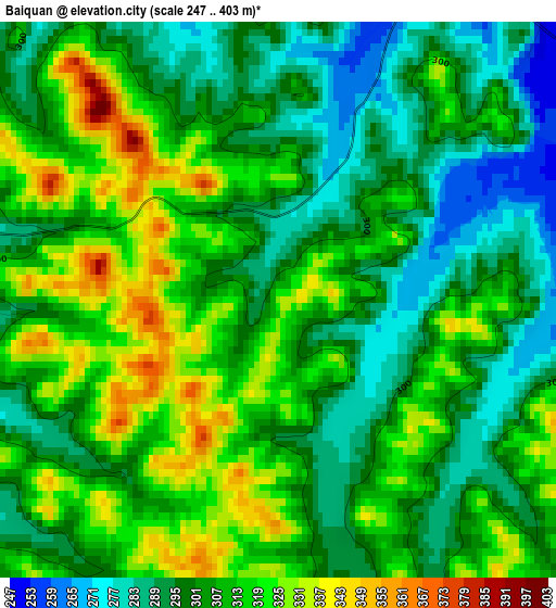
Below is the Elevation map of Baiquan, which displays elevation range with different colors. Scale of the first map is from 247 to 403 m (810 to 1322 ft) with average elevation of 305.7 meters (=1003 ft) [note 1]
These maps also provides idea of topography and contour of this city, they are displayed at different zoom levels. More info about maps, scale and edge coordinates you can find below images.
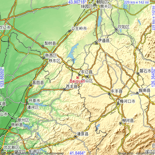
| \ | Map #1 | Topo.Map |
| Scale [m] | 247..403 m | × |
| Scale [ft] | 810..1322 ft | × |
| Average | 305.7 m = 1003 ft | × |
| Width | 7.16 km = 4.4 mi | 229.1 km = 142.4 mi |
| Height | 7.16 km = 4.4 mi | 229.1 km = 142.4 mi |
| ↑Max Latitude | 42.917571° | 43.90715° |
| Latitude at center | 42.88538° | 42.88538° |
| ↓Min Latitude | 42.853172° | 41.8464° |
| ← Min Longitude | 124.914325° | 123.55202° |
| Longitude center | 124.95827° | 124.95827° |
| →Max Longitude | 125.002215° | 126.36452° |
Nearby cities:
Cities around Baiquan sort by population:
• Siping elevation 176 m
56.3 km,  303°
303°
• Liaoyuan 263 m
14.6 km,  82°
82°
• Gongzhuling 211 m
69.3 km,  350°
350°
• Kaiyuan 91 m
84.6 km,  242°
242°
• Meihekou 329 m
70.8 km,  124°
124°
• Panshi 323 m
89.6 km,  85°
85°
• Chaoyang 297 m
90.6 km,  105°
105°
• Changtu 135 m
71.3 km,  260°
260°
• Dongfeng 350 m
52.8 km, 121°
• Lishu 168 m
69.2 km,  312°
312°
• Xifeng 197 m
25.3 km,  229°
229°
• Yitong 249 m
56.2 km,  29°
29°
Multilingual:
 En español:
Baiquan elevación 336 m.
 En France:
Baiquan élévation 336 m.


Sources and notes:
- [note 1] Map square and city borders are not equal. Map elevation data is calculated only from area inside that square.
- [src 1] Elevation data from geonames database provided with same terms of usage.
- [src 2] The elevation map of Baiquan is generated using elevation data from NASA's 3 arcsec (90m) resolution SRTM data.
- [src 3] Base (background) map © OpenStreetMap contributors tiles are generated by Geofabrik and OpenTopoMap.
Copyright & License:
This Baiquan Elevation Map is licensed under CC BY-SA. You may reuse any part from this page, if you give a proper credit by linking to this URL:
 More info on terms of use page.