Meihekou elevation
Meihekou (Jilin), China elevation is 329 meters and Meihekou elevation in feet is 1079 ft above sea level [src 1]. Meihekou is a populated place (feature code) with elevation that is 229 meters (751 ft) smaller than average city elevation in China.
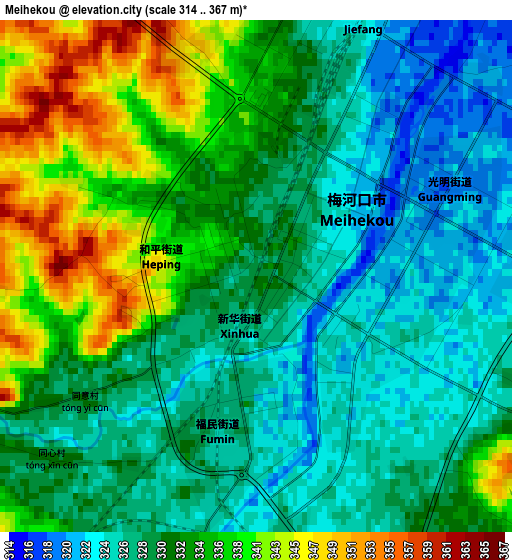
Below is the Elevation map of Meihekou, which displays elevation range with different colors. Scale of the first map is from 314 to 367 m (1030 to 1204 ft) with average elevation of 331.7 meters (=1088 ft) [note 1]
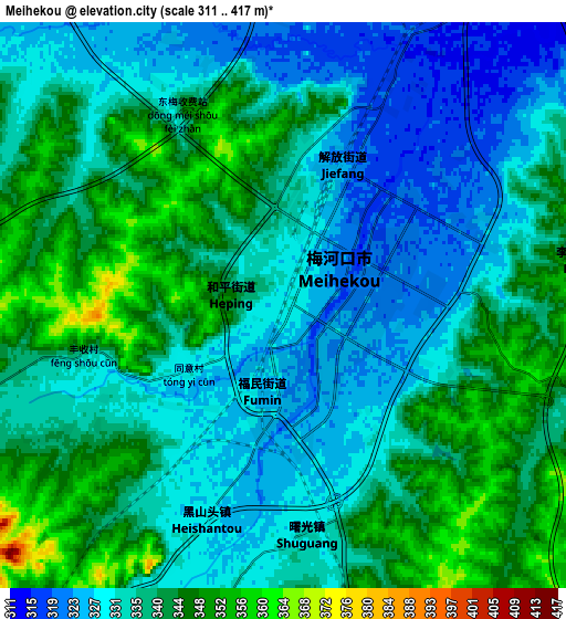
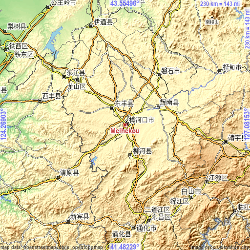
These maps also provides idea of topography and contour of this city, they are displayed at different zoom levels. More info about maps, scale and edge coordinates you can find below images.
| \ | Map #1 | Map #2 | Topo.Map |
| Scale [m] | 314..367 m | 311..417 m | × |
| Scale [ft] | 1030..1204 ft | 1020..1368 ft | × |
| Average | 331.7 m = 1088 ft | 336.5 m = 1104 ft | × |
| Width | 7.2 km = 4.5 mi | 14.4 km = 8.9 mi | 230.5 km = 143.2 mi |
| Height | 7.2 km = 4.5 mi | 14.4 km = 8.9 mi | 230.5 km = 143.2 mi |
| ↑Max Latitude | 42.559597° | 42.591958° | 43.55496° |
| Latitude at center | 42.52722° | 42.52722° | 42.52722° |
| ↓Min Latitude | 42.494826° | 42.462415° | 41.48229° |
| ← Min Longitude | 125.631335° | 125.587389° | 124.26903° |
| Longitude center | 125.67528° | 125.67528° | 125.67528° |
| →Max Longitude | 125.719225° | 125.763171° | 127.08153° |
Nearby cities:
Cities around Meihekou sort by population:
• Liaoyuan elevation 263 m
60.8 km,  313°
313°
• Baishan 471 m
89.7 km,  136°
136°
• Panshi 323 m
55.6 km,  33°
33°
• Chaoyang 297 m
32.4 km,  62°
62°
• Dongfeng 350 m
18.4 km, 313°
• Liuhe 399 m
32.1 km,  173°
173°
• Sanchazi 558 m
90.8 km,  123°
123°
• Huinan 315 m
49.1 km,  77°
77°
• Xifeng 197 m
81.4 km,  286°
286°
• Erdaojiang 407 m
88.5 km,  160°
160°
• Yantongshan 250 m
89.3 km,  17°
17°
• Baiquan 336 m
70.8 km,  304°
304°
Multilingual:
 En español:
Meihekou elevación 329 m.
 En France:
Meihekou élévation 329 m.
 Auf Deutsch:
Meihekou höhe über dem Meeresspiegel ist 329 m.

Sources and notes:
- [note 1] Map square and city borders are not equal. Map elevation data is calculated only from area inside that square.
- [src 1] Elevation data from geonames database provided with same terms of usage.
- [src 2] The elevation map of Meihekou is generated using elevation data from NASA's 3 arcsec (90m) resolution SRTM data.
- [src 3] Base (background) map © OpenStreetMap contributors tiles are generated by Geofabrik and OpenTopoMap.
Copyright & License:
This Meihekou Elevation Map is licensed under CC BY-SA. You may reuse any part from this page, if you give a proper credit by linking to this URL:
 More info on terms of use page.