Dage elevation
Dage (Hebei), China elevation is 651 meters and Dage elevation in feet is 2136 ft above sea level [src 1]. Dage is a seat of a third-order administrative division (feature code) with elevation that is 93 meters (305 ft) bigger than average city elevation in China.
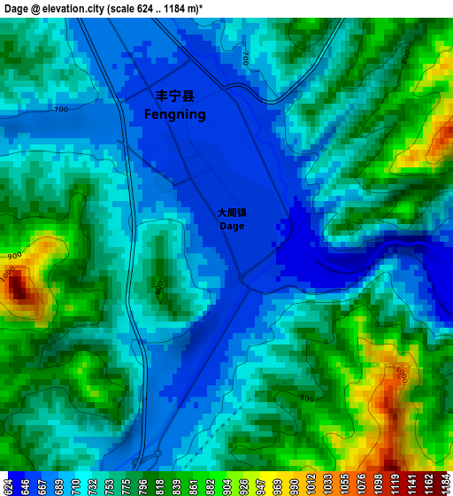
Below is the Elevation map of Dage, which displays elevation range with different colors. Scale of the first map is from 624 to 1184 m (2047 to 3885 ft) with average elevation of 757.5 meters (=2485 ft) [note 1]
These maps also provides idea of topography and contour of this city, they are displayed at different zoom levels. More info about maps, scale and edge coordinates you can find below images.
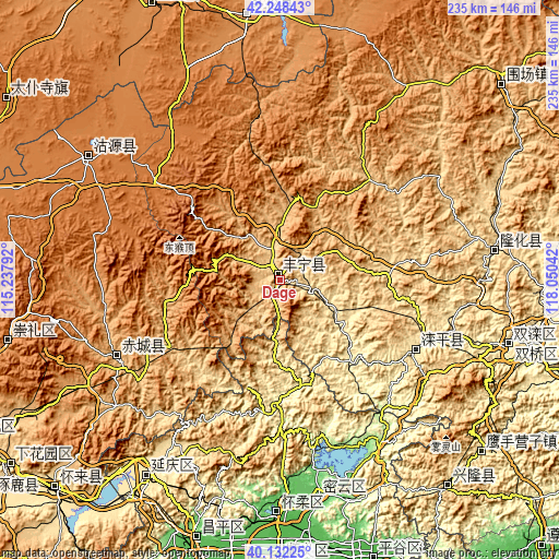
| \ | Map #1 | Topo.Map |
| Scale [m] | 624..1184 m | × |
| Scale [ft] | 2047..3885 ft | × |
| Average | 757.5 m = 2485 ft | × |
| Width | 7.35 km = 4.6 mi | 235.3 km = 146.2 mi |
| Height | 7.35 km = 4.6 mi | 235.3 km = 146.2 mi |
| ↑Max Latitude | 41.231947° | 42.24843° |
| Latitude at center | 41.19889° | 41.19889° |
| ↓Min Latitude | 41.165816° | 40.13225° |
| ← Min Longitude | 116.600225° | 115.23792° |
| Longitude center | 116.64417° | 116.64417° |
| →Max Longitude | 116.688115° | 118.05042° |
Nearby cities:
Cities around Dage sort by population:
• Chengde elevation 318 m
113.6 km,  103°
103°
• Xinglong 570 m
113 km,  139°
139°
• Yingshouyingzi 473 m
111.8 km,  130°
130°
• Duolun 1240 m
110.6 km,  353°
353°
• Shuangtashan 365 m
100.4 km,  106°
106°
• Yanqing 487 m
99.7 km,  214°
214°
• Longshan 63 m
97.7 km,  180°
180°
• Pingdingbu 1412 m
94.4 km,  303°
303°
• Gulou 73 m
93.5 km,  170°
170°
• Longhua 553 m
91.2 km,  82°
82°
• Chicheng 939 m
77.4 km,  241°
241°
• Luanping 526 m
62.1 km,  120°
120°
Multilingual:
 En español:
Dage elevación 651 m.
 En France:
Dage élévation 651 m.


Sources and notes:
- [note 1] Map square and city borders are not equal. Map elevation data is calculated only from area inside that square.
- [src 1] Elevation data from geonames database provided with same terms of usage.
- [src 2] The elevation map of Dage is generated using elevation data from NASA's 3 arcsec (90m) resolution SRTM data.
- [src 3] Base (background) map © OpenStreetMap contributors tiles are generated by Geofabrik and OpenTopoMap.
Copyright & License:
This Dage Elevation Map is licensed under CC BY-SA. You may reuse any part from this page, if you give a proper credit by linking to this URL:
 More info on terms of use page.