Chengde elevation
Chengde (Hebei, Chengde Prefecture), China elevation is 318 meters and Chengde elevation in feet is 1043 ft above sea level [src 1]. Chengde is a populated place (feature code) with elevation that is 240 meters (787 ft) smaller than average city elevation in China.
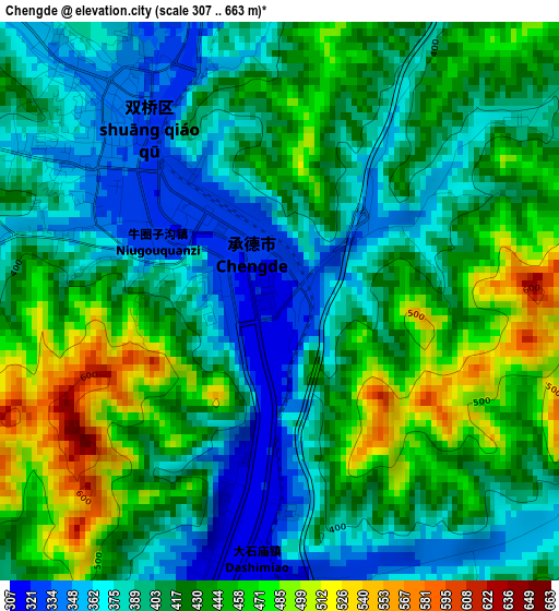
Below is the Elevation map of Chengde, which displays elevation range with different colors. Scale of the first map is from 307 to 663 m (1007 to 2175 ft) with average elevation of 416.1 meters (=1365 ft) [note 1]
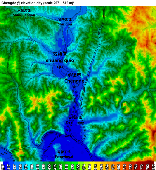
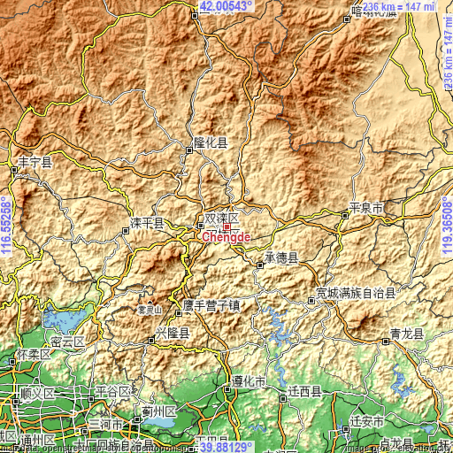
These maps also provides idea of topography and contour of this city, they are displayed at different zoom levels. More info about maps, scale and edge coordinates you can find below images.
| \ | Map #1 | Map #2 | Topo.Map |
| Scale [m] | 307..663 m | 297..812 m | × |
| Scale [ft] | 1007..2175 ft | 974..2664 ft | × |
| Average | 416.1 m = 1365 ft | 450.6 m = 1478 ft | × |
| Width | 7.38 km = 4.6 mi | 14.76 km = 9.2 mi | 236.2 km = 146.8 mi |
| Height | 7.38 km = 4.6 mi | 14.76 km = 9.2 mi | 236.2 km = 146.8 mi |
| ↑Max Latitude | 40.985082° | 41.018247° | 42.00543° |
| Latitude at center | 40.9519° | 40.9519° | 40.9519° |
| ↓Min Latitude | 40.918702° | 40.885486° | 39.88129° |
| ← Min Longitude | 117.914885° | 117.870939° | 116.55258° |
| Longitude center | 117.95883° | 117.95883° | 117.95883° |
| →Max Longitude | 118.002775° | 118.046721° | 119.36508° |
Nearby cities:
Cities around Chengde sort by population:
• Songling elevation 134 m
77.8 km,  160°
160°
• Yangezhuang 24 m
108.6 km,  192°
192°
• Weichang 887 m
111.8 km,  350°
350°
• Qinglong 239 m
102.9 km,  126°
126°
• Zunhua 52 m
85.9 km,  180°
180°
• Xinglong 570 m
70.3 km,  212°
212°
• Pingquan 499 m
61.1 km,  84°
84°
• Kuancheng 303 m
58.5 km, 131°
• Luanping 526 m
56.9 km,  266°
266°
• Yingshouyingzi 473 m
51.1 km, 209°
• Longhua 553 m
44.5 km,  333°
333°
• Shuangtashan 365 m
13.8 km, 268°
Multilingual:
 En español:
Chengdé elevación 318 m.
 En France:
Chengde élévation 318 m.


Sources and notes:
- [note 1] Map square and city borders are not equal. Map elevation data is calculated only from area inside that square.
- [src 1] Elevation data from geonames database provided with same terms of usage.
- [src 2] The elevation map of Chengde is generated using elevation data from NASA's 3 arcsec (90m) resolution SRTM data.
- [src 3] Base (background) map © OpenStreetMap contributors tiles are generated by Geofabrik and OpenTopoMap.
Copyright & License:
This Chengde Elevation Map is licensed under CC BY-SA. You may reuse any part from this page, if you give a proper credit by linking to this URL:
 More info on terms of use page.