Xinglong elevation
Xinglong (Hebei), China elevation is 570 meters and Xinglong elevation in feet is 1870 ft above sea level [src 1]. Xinglong is a seat of a third-order administrative division (feature code) with elevation that is 12 meters (39 ft) bigger than average city elevation in China.
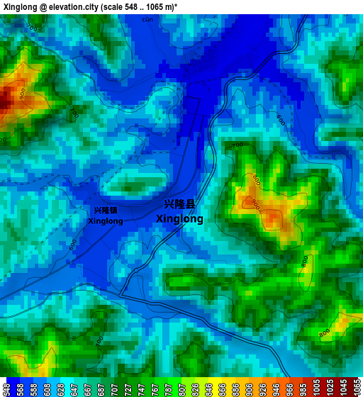
Below is the Elevation map of Xinglong, which displays elevation range with different colors. Scale of the first map is from 548 to 1065 m (1798 to 3494 ft) with average elevation of 659.7 meters (=2164 ft) [note 1]
These maps also provides idea of topography and contour of this city, they are displayed at different zoom levels. More info about maps, scale and edge coordinates you can find below images.
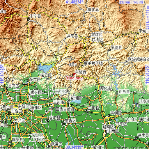
| \ | Map #1 | Topo.Map |
| Scale [m] | 548..1065 m | × |
| Scale [ft] | 1798..3494 ft | × |
| Average | 659.7 m = 2164 ft | × |
| Width | 7.44 km = 4.6 mi | 238.1 km = 147.9 mi |
| Height | 7.44 km = 4.6 mi | 238.1 km = 147.9 mi |
| ↑Max Latitude | 40.453728° | 41.48234° |
| Latitude at center | 40.42028° | 40.42028° |
| ↓Min Latitude | 40.386816° | 39.34119° |
| ← Min Longitude | 117.463555° | 116.10125° |
| Longitude center | 117.5075° | 117.5075° |
| →Max Longitude | 117.551445° | 118.91375° |
Nearby cities:
Cities around Xinglong sort by population:
• Bangjun elevation 31 m
52 km,  203°
203°
• Yangezhuang 24 m
49.6 km,  161°
161°
• Dabao’anzhen 9 m
58 km,  182°
182°
• Dong’erying 15 m
55 km, 200°
• Dongzhaogezhuang 10 m
53.7 km,  192°
192°
• Baijian 31 m
53.7 km,  208°
208°
• Touying 21 m
56.4 km, 205°
• Yinliu 14 m
49.6 km, 190°
• Gulou 73 m
57.3 km,  264°
264°
• Zunhua 52 m
46.7 km,  125°
125°
• Binhe 36 m
46.5 km,  226°
226°
• Yingshouyingzi 473 m
19.6 km,  41°
41°
Multilingual:
 En español:
Xinglong elevación 570 m.
 En France:
Xinglong élévation 570 m.
 Auf Deutsch:
Xinglong höhe über dem Meeresspiegel ist 570 m.

Sources and notes:
- [note 1] Map square and city borders are not equal. Map elevation data is calculated only from area inside that square.
- [src 1] Elevation data from geonames database provided with same terms of usage.
- [src 2] The elevation map of Xinglong is generated using elevation data from NASA's 3 arcsec (90m) resolution SRTM data.
- [src 3] Base (background) map © OpenStreetMap contributors tiles are generated by Geofabrik and OpenTopoMap.
Copyright & License:
This Xinglong Elevation Map is licensed under CC BY-SA. You may reuse any part from this page, if you give a proper credit by linking to this URL:
 More info on terms of use page.