Kuancheng elevation
Kuancheng (Hebei), China elevation is 303 meters and Kuancheng elevation in feet is 994 ft above sea level [src 1]. Kuancheng is a seat of a third-order administrative division (feature code) with elevation that is 255 meters (837 ft) smaller than average city elevation in China.
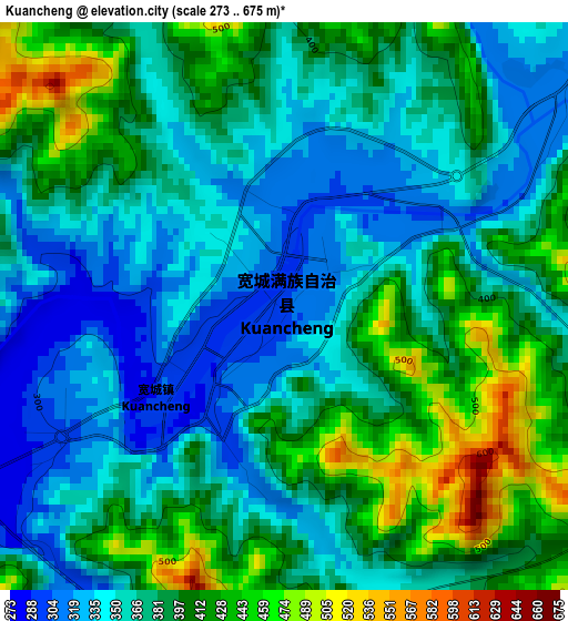
Below is the Elevation map of Kuancheng, which displays elevation range with different colors. Scale of the first map is from 273 to 675 m (896 to 2215 ft) with average elevation of 379.3 meters (=1244 ft) [note 1]
These maps also provides idea of topography and contour of this city, they are displayed at different zoom levels. More info about maps, scale and edge coordinates you can find below images.
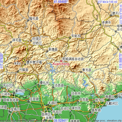
| \ | Map #1 | Topo.Map |
| Scale [m] | 273..675 m | × |
| Scale [ft] | 896..2215 ft | × |
| Average | 379.3 m = 1244 ft | × |
| Width | 7.42 km = 4.6 mi | 237.4 km = 147.5 mi |
| Height | 7.42 km = 4.6 mi | 237.4 km = 147.5 mi |
| ↑Max Latitude | 40.638915° | 41.66465° |
| Latitude at center | 40.60556° | 40.60556° |
| ↓Min Latitude | 40.572188° | 39.52941° |
| ← Min Longitude | 118.438555° | 117.07625° |
| Longitude center | 118.4825° | 118.4825° |
| →Max Longitude | 118.526445° | 119.88875° |
Nearby cities:
Cities around Kuancheng sort by population:
• Chengde elevation 318 m
58.5 km,  311°
311°
• Zhaogezhuang 61 m
93.6 km,  183°
183°
• Tangjiazhuang 70 m
95.9 km, 181°
• Fengrun 28 m
91.3 km,  199°
199°
• Songling 134 m
39.2 km,  207°
207°
• Yangezhuang 24 m
95.4 km,  224°
224°
• Xinglong 570 m
85 km,  255°
255°
• Yingshouyingzi 473 m
69.6 km,  265°
265°
• Shuangtashan 365 m
69.3 km,  303°
303°
• Zunhua 52 m
64.9 km, 223°
• Pingquan 499 m
47.3 km,  21°
21°
• Qinglong 239 m
44.9 km,  119°
119°
Multilingual:
 En español:
Kuancheng elevación 303 m.
 En France:
Kuancheng élévation 303 m.
 Auf Deutsch:
Kuancheng höhe über dem Meeresspiegel ist 303 m.

Sources and notes:
- [note 1] Map square and city borders are not equal. Map elevation data is calculated only from area inside that square.
- [src 1] Elevation data from geonames database provided with same terms of usage.
- [src 2] The elevation map of Kuancheng is generated using elevation data from NASA's 3 arcsec (90m) resolution SRTM data.
- [src 3] Base (background) map © OpenStreetMap contributors tiles are generated by Geofabrik and OpenTopoMap.
Copyright & License:
This Kuancheng Elevation Map is licensed under CC BY-SA. You may reuse any part from this page, if you give a proper credit by linking to this URL:
 More info on terms of use page.