Fengrun elevation
Fengrun (Hebei), China elevation is 28 meters and Fengrun elevation in feet is 92 ft above sea level [src 1]. Fengrun is a populated place (feature code) with elevation that is 530 meters (1739 ft) smaller than average city elevation in China.
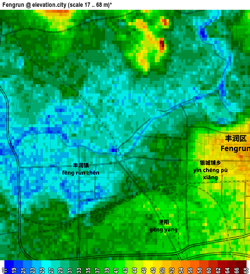
Below is the Elevation map of Fengrun, which displays elevation range with different colors. Scale of the first map is from 17 to 68 m (56 to 223 ft) with average elevation of 33.2 meters (=109 ft) [note 1]
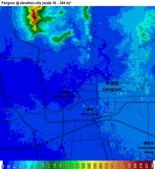
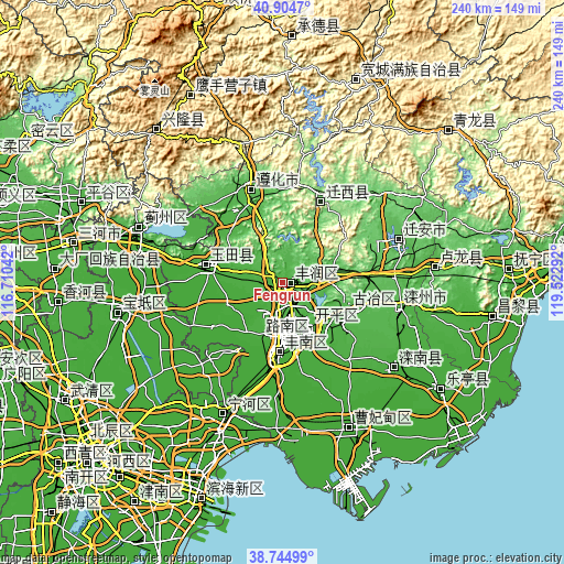
These maps also provides idea of topography and contour of this city, they are displayed at different zoom levels. More info about maps, scale and edge coordinates you can find below images.
| \ | Map #1 | Map #2 | Topo.Map |
| Scale [m] | 17..68 m | 16..344 m | × |
| Scale [ft] | 56..223 ft | 52..1129 ft | × |
| Average | 33.2 m = 109 ft | 42.1 m = 138 ft | × |
| Width | 7.5 km = 4.7 mi | 15.01 km = 9.3 mi | 240.1 km = 149.2 mi |
| Height | 7.5 km = 4.7 mi | 15.01 km = 9.3 mi | 240.1 km = 149.2 mi |
| ↑Max Latitude | 39.867068° | 39.900789° | 40.9047° |
| Latitude at center | 39.83333° | 39.83333° | 39.83333° |
| ↓Min Latitude | 39.799576° | 39.765805° | 38.74499° |
| ← Min Longitude | 118.072725° | 118.028779° | 116.71042° |
| Longitude center | 118.11667° | 118.11667° | 118.11667° |
| →Max Longitude | 118.160615° | 118.204561° | 119.52292° |
Nearby cities:
Cities around Fengrun sort by population:
• Tangshan elevation 36 m
23 km,  165°
165°
• Linxi 46 m
31.5 km,  115°
115°
• Zhaogezhuang 61 m
26.3 km,  106°
106°
• Tangjiazhuang 70 m
30.3 km, 109°
• Guye 44 m
30 km, 112°
• Fengtai 5 m
43.9 km,  225°
225°
• Yangezhuang 24 m
40.6 km,  296°
296°
• Nanmaizhu 6 m
48.6 km,  220°
220°
• Penguanzhuang 6 m
46.7 km,  213°
213°
• Zunhua 52 m
40.7 km,  340°
340°
• Yutian 19 m
32.6 km,  278°
278°
• Kaiping 30 m
20.8 km,  146°
146°
Multilingual:
 En español:
Fengrun elevación 28 m.
 En France:
Fengrun élévation 28 m.


Sources and notes:
- [note 1] Map square and city borders are not equal. Map elevation data is calculated only from area inside that square.
- [src 1] Elevation data from geonames database provided with same terms of usage.
- [src 2] The elevation map of Fengrun is generated using elevation data from NASA's 3 arcsec (90m) resolution SRTM data.
- [src 3] Base (background) map © OpenStreetMap contributors tiles are generated by Geofabrik and OpenTopoMap.
Copyright & License:
This Fengrun Elevation Map is licensed under CC BY-SA. You may reuse any part from this page, if you give a proper credit by linking to this URL:
 More info on terms of use page.