Chicheng elevation
Chicheng (Hebei), China elevation is 939 meters and Chicheng elevation in feet is 3081 ft above sea level [src 1]. Chicheng is a seat of a third-order administrative division (feature code) with elevation that is 381 meters (1250 ft) bigger than average city elevation in China.
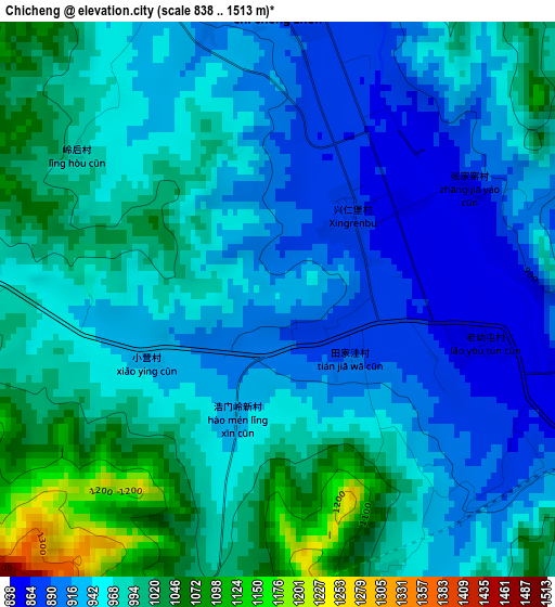
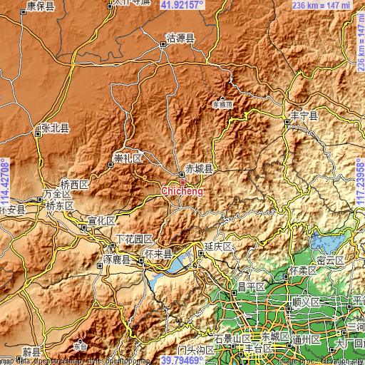
Below is the Elevation map of Chicheng, which displays elevation range with different colors. Scale of the first map is from 838 to 1513 m (2749 to 4964 ft) with average elevation of 961.5 meters (=3155 ft) [note 1]
These maps also provides idea of topography and contour of this city, they are displayed at different zoom levels. More info about maps, scale and edge coordinates you can find below images.
| \ | Map #1 | Topo.Map |
| Scale [m] | 838..1513 m | × |
| Scale [ft] | 2749..4964 ft | × |
| Average | 961.5 m = 3155 ft | × |
| Width | 7.39 km = 4.6 mi | 236.5 km = 147 mi |
| Height | 7.39 km = 4.6 mi | 236.5 km = 147 mi |
| ↑Max Latitude | 40.899895° | 41.92157° |
| Latitude at center | 40.86667° | 40.86667° |
| ↓Min Latitude | 40.833429° | 39.79469° |
| ← Min Longitude | 115.789385° | 114.42708° |
| Longitude center | 115.83333° | 115.83333° |
| →Max Longitude | 115.877275° | 117.23958° |
Nearby cities:
Cities around Chicheng sort by population:
• Zhangjiakou elevation 758 m
80.5 km,  265°
265°
• Zhangjiakou Shi Xuanhua Qu 610 m
72.3 km,  246°
246°
• Changping 68 m
79.9 km,  154°
154°
• Longshan 63 m
90.6 km,  132°
132°
• Pingdingbu 1412 m
89.5 km,  352°
352°
• Chengbei 68 m
79.6 km, 154°
• Dage 651 m
77.4 km,  61°
61°
• Zhuolu 532 m
76 km,  223°
223°
• Chengzhen 577 m
64.2 km,  227°
227°
• Shacheng 515 m
59.4 km,  207°
207°
• Xiwanzi 1245 m
48.5 km,  283°
283°
• Yanqing 487 m
46.6 km,  165°
165°
Multilingual:
 En español:
Chicheng elevación 939 m.
 En France:
Chicheng élévation 939 m.
 Auf Deutsch:
Chicheng höhe über dem Meeresspiegel ist 939 m.

Sources and notes:
- [note 1] Map square and city borders are not equal. Map elevation data is calculated only from area inside that square.
- [src 1] Elevation data from geonames database provided with same terms of usage.
- [src 2] The elevation map of Chicheng is generated using elevation data from NASA's 3 arcsec (90m) resolution SRTM data.
- [src 3] Base (background) map © OpenStreetMap contributors tiles are generated by Geofabrik and OpenTopoMap.
Copyright & License:
This Chicheng Elevation Map is licensed under CC BY-SA. You may reuse any part from this page, if you give a proper credit by linking to this URL:
 More info on terms of use page.