Shacheng elevation
Shacheng (Hebei), China elevation is 515 meters and Shacheng elevation in feet is 1690 ft above sea level [src 1]. Shacheng is a seat of a third-order administrative division (feature code) with elevation that is 43 meters (141 ft) smaller than average city elevation in China.
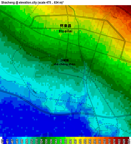
Below is the Elevation map of Shacheng, which displays elevation range with different colors. Scale of the first map is from 475 to 634 m (1558 to 2080 ft) with average elevation of 524.5 meters (=1721 ft) [note 1]
These maps also provides idea of topography and contour of this city, they are displayed at different zoom levels. More info about maps, scale and edge coordinates you can find below images.
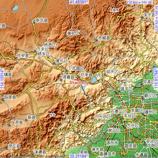
| \ | Map #1 | Topo.Map |
| Scale [m] | 475..634 m | × |
| Scale [ft] | 1558..2080 ft | × |
| Average | 524.5 m = 1721 ft | × |
| Width | 7.44 km = 4.6 mi | 238.2 km = 148 mi |
| Height | 7.44 km = 4.6 mi | 238.2 km = 148 mi |
| ↑Max Latitude | 40.424852° | 41.45391° |
| Latitude at center | 40.39139° | 40.39139° |
| ↓Min Latitude | 40.357911° | 39.31184° |
| ← Min Longitude | 115.467445° | 114.10514° |
| Longitude center | 115.51139° | 115.51139° |
| →Max Longitude | 115.555335° | 116.91764° |
Nearby cities:
Cities around Shacheng sort by population:
• Zhangjiakou elevation 758 m
70.8 km,  311°
311°
• Zhangjiakou Shi Xuanhua Qu 610 m
46.4 km,  301°
301°
• Mentougou 111 m
70.6 km,  135°
135°
• Changping 68 m
64.4 km,  107°
107°
• Kongjiazhuang 734 m
77.5 km, 301°
• Dayu 105 m
70.9 km, 135°
• Xiwanzi 1245 m
67.6 km,  342°
342°
• Chengbei 68 m
65 km, 106°
• Chicheng 939 m
59.4 km,  27°
27°
• Yanqing 487 m
39.7 km,  78°
78°
• Zhuolu 532 m
25.1 km,  264°
264°
• Chengzhen 577 m
22.8 km, 295°
Multilingual:
 En español:
Shacheng elevación 515 m.
 En France:
Shacheng élévation 515 m.
 Auf Deutsch:
Shacheng höhe über dem Meeresspiegel ist 515 m.

Sources and notes:
- [note 1] Map square and city borders are not equal. Map elevation data is calculated only from area inside that square.
- [src 1] Elevation data from geonames database provided with same terms of usage.
- [src 2] The elevation map of Shacheng is generated using elevation data from NASA's 3 arcsec (90m) resolution SRTM data.
- [src 3] Base (background) map © OpenStreetMap contributors tiles are generated by Geofabrik and OpenTopoMap.
Copyright & License:
This Shacheng Elevation Map is licensed under CC BY-SA. You may reuse any part from this page, if you give a proper credit by linking to this URL:
 More info on terms of use page.