Kongjiazhuang elevation
Kongjiazhuang (Hebei), China elevation is 734 meters and Kongjiazhuang elevation in feet is 2408 ft above sea level [src 1]. Kongjiazhuang is a seat of a third-order administrative division (feature code) with elevation that is 176 meters (577 ft) bigger than average city elevation in China.
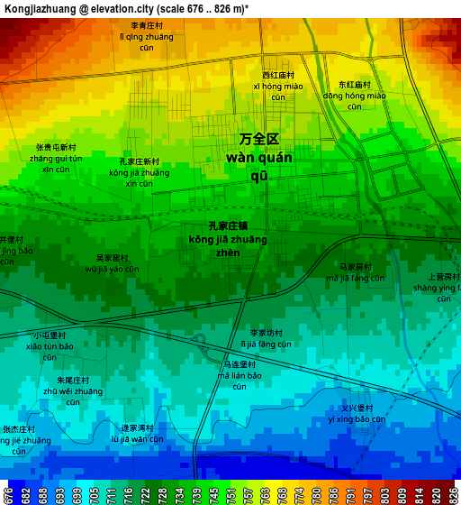
Below is the Elevation map of Kongjiazhuang, which displays elevation range with different colors. Scale of the first map is from 676 to 826 m (2218 to 2710 ft) with average elevation of 732.2 meters (=2402 ft) [note 1]
These maps also provides idea of topography and contour of this city, they are displayed at different zoom levels. More info about maps, scale and edge coordinates you can find below images.
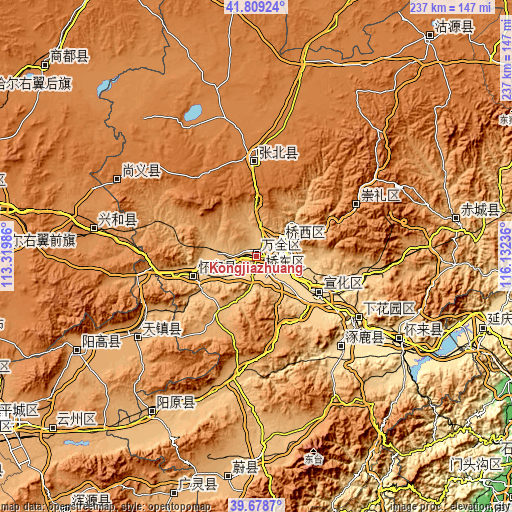
| \ | Map #1 | Topo.Map |
| Scale [m] | 676..826 m | × |
| Scale [ft] | 2218..2710 ft | × |
| Average | 732.2 m = 2402 ft | × |
| Width | 7.4 km = 4.6 mi | 236.9 km = 147.2 mi |
| Height | 7.4 km = 4.6 mi | 236.9 km = 147.2 mi |
| ↑Max Latitude | 40.785782° | 41.80924° |
| Latitude at center | 40.7525° | 40.7525° |
| ↓Min Latitude | 40.719201° | 39.6787° |
| ← Min Longitude | 114.682165° | 113.31986° |
| Longitude center | 114.72611° | 114.72611° |
| →Max Longitude | 114.770055° | 116.13236° |
Nearby cities:
Cities around Kongjiazhuang sort by population:
• Zhangjiakou elevation 758 m
14.4 km,  63°
63°
• Zhangjiakou Shi Xuanhua Qu 610 m
31.2 km,  120°
120°
• Xicheng 924 m
86 km,  213°
213°
• Shacheng 515 m
77.5 km, 121°
• Nanhaoqian 1348 m
73.3 km,  298°
298°
• Xinghe Chengguanzhen 1244 m
72.2 km,  280°
280°
• Yuquan 1063 m
72.2 km,  241°
241°
• Zhuolu 532 m
59.4 km,  135°
135°
• Chengzhen 577 m
54.9 km, 123°
• Xiwanzi 1245 m
52 km, 62°
• Zhangbei 1396 m
44.5 km,  358°
358°
• Chaigoubu 799 m
28.1 km,  250°
250°
Multilingual:
 En español:
Kongjiazhuang elevación 734 m.
 En France:
Kongjiazhuang élévation 734 m.
 Auf Deutsch:
Kongjiazhuang höhe über dem Meeresspiegel ist 734 m.

Sources and notes:
- [note 1] Map square and city borders are not equal. Map elevation data is calculated only from area inside that square.
- [src 1] Elevation data from geonames database provided with same terms of usage.
- [src 2] The elevation map of Kongjiazhuang is generated using elevation data from NASA's 3 arcsec (90m) resolution SRTM data.
- [src 3] Base (background) map © OpenStreetMap contributors tiles are generated by Geofabrik and OpenTopoMap.
Copyright & License:
This Kongjiazhuang Elevation Map is licensed under CC BY-SA. You may reuse any part from this page, if you give a proper credit by linking to this URL:
 More info on terms of use page.