Kailu elevation
Kailu (Inner Mongolia), China elevation is 251 meters and Kailu elevation in feet is 823 ft above sea level [src 1]. Kailu is a seat of a third-order administrative division (feature code) with elevation that is 307 meters (1007 ft) smaller than average city elevation in China.
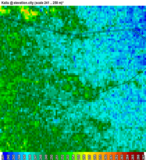
Below is the Elevation map of Kailu, which displays elevation range with different colors. Scale of the first map is from 241 to 258 m (791 to 846 ft) with average elevation of 247.1 meters (=811 ft) [note 1]
These maps also provides idea of topography and contour of this city, they are displayed at different zoom levels. More info about maps, scale and edge coordinates you can find below images.
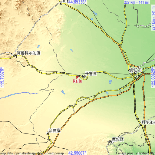
| \ | Map #1 | Topo.Map |
| Scale [m] | 241..258 m | × |
| Scale [ft] | 791..846 ft | × |
| Average | 247.1 m = 811 ft | × |
| Width | 7.08 km = 4.4 mi | 226.5 km = 140.7 mi |
| Height | 7.08 km = 4.4 mi | 226.5 km = 140.7 mi |
| ↑Max Latitude | 43.615154° | 44.59336° |
| Latitude at center | 43.58333° | 43.58333° |
| ↓Min Latitude | 43.551489° | 42.55607° |
| ← Min Longitude | 121.156055° | 119.79375° |
| Longitude center | 121.2° | 121.2° |
| →Max Longitude | 121.243945° | 122.60625° |
Nearby cities:
Cities around Kailu sort by population:
• Fuxin elevation 142 m
178.3 km,  167°
167°
• Tongliao 182 m
85.8 km,  87°
87°
• Zhengjiatun 117 m
186.1 km, 92°
• Wudan 633 m
190.4 km,  247°
247°
• Xinhui 574 m
179.2 km,  216°
216°
• Baokang 146 m
179 km,  70°
70°
• Bayan Huxu 291 m
174.9 km,  5°
5°
• Lindong 1019 m
167.9 km,  285°
285°
• Lubei 331 m
115.7 km,  350°
350°
• Kulun 266 m
105.7 km,  153°
153°
• Tianshan 365 m
95.1 km, 290°
• Daqin Tal 365 m
88.3 km,  208°
208°
Multilingual:
 En español:
Kailu elevación 251 m.
 En France:
Kailu élévation 251 m.


Sources and notes:
- [note 1] Map square and city borders are not equal. Map elevation data is calculated only from area inside that square.
- [src 1] Elevation data from geonames database provided with same terms of usage.
- [src 2] The elevation map of Kailu is generated using elevation data from NASA's 3 arcsec (90m) resolution SRTM data.
- [src 3] Base (background) map © OpenStreetMap contributors tiles are generated by Geofabrik and OpenTopoMap.
Copyright & License:
This Kailu Elevation Map is licensed under CC BY-SA. You may reuse any part from this page, if you give a proper credit by linking to this URL:
 More info on terms of use page.