Fuxin elevation
Fuxin (Liaoning, Fuxin Shi), China elevation is 142 meters and Fuxin elevation in feet is 466 ft above sea level [src 1]. Fuxin is a populated place (feature code) with elevation that is 416 meters (1365 ft) smaller than average city elevation in China.
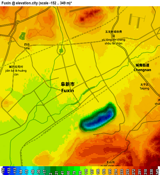
Below is the Elevation map of Fuxin, which displays elevation range with different colors. Scale of the first map is from -152 to 179 m (-499 to 587 ft) with average elevation of 130.1 meters (=427 ft) [note 1]
These maps also provides idea of topography and contour of this city, they are displayed at different zoom levels. More info about maps, scale and edge coordinates you can find below images.

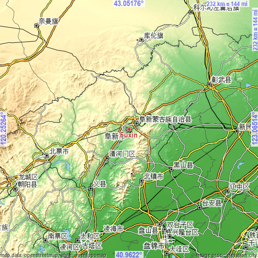
| \ | Map #1 | Map #2 | Topo.Map |
| Scale [m] | -152..179 m | -152..349 m | × |
| Scale [ft] | -499..587 ft | -499..1145 ft | × |
| Average | 130.1 m = 427 ft | 164.1 m = 538 ft | × |
| Width | 7.26 km = 4.5 mi | 14.52 km = 9 mi | 232.3 km = 144.3 mi |
| Height | 7.26 km = 4.5 mi | 14.52 km = 9 mi | 232.3 km = 144.3 mi |
| ↑Max Latitude | 42.048201° | 42.080826° | 43.05176° |
| Latitude at center | 42.01556° | 42.01556° | 42.01556° |
| ↓Min Latitude | 41.982902° | 41.950227° | 40.9622° |
| ← Min Longitude | 121.614945° | 121.570999° | 120.25264° |
| Longitude center | 121.65889° | 121.65889° | 121.65889° |
| →Max Longitude | 121.702835° | 121.746781° | 123.06514° |
Nearby cities:
Cities around Fuxin sort by population:
• Panshan elevation 9 m
97.6 km,  160°
160°
• Jinzhou 26 m
109.7 km,  203°
203°
• Chaoyang 162 m
111.1 km,  243°
243°
• Nanpiao 98 m
127.1 km,  216°
216°
• Beipiao 266 m
76.9 km,  251°
251°
• Xinmin 34 m
96.4 km,  91°
91°
• Heishan 26 m
52.3 km,  133°
133°
• Linghai 27 m
97.6 km,  194°
194°
• Liaozhong 16 m
105 km,  122°
122°
• Daqin Tal 365 m
126.1 km,  320°
320°
• Dawa 5 m
118.6 km, 163°
• Kulun 266 m
80.1 km,  6°
6°
Multilingual:
 En español:
Fuxin elevación 142 m.
 En France:
Fuxin élévation 142 m.


Sources and notes:
- [note 1] Map square and city borders are not equal. Map elevation data is calculated only from area inside that square.
- [src 1] Elevation data from geonames database provided with same terms of usage.
- [src 2] The elevation map of Fuxin is generated using elevation data from NASA's 3 arcsec (90m) resolution SRTM data.
- [src 3] Base (background) map © OpenStreetMap contributors tiles are generated by Geofabrik and OpenTopoMap.
Copyright & License:
This Fuxin Elevation Map is licensed under CC BY-SA. You may reuse any part from this page, if you give a proper credit by linking to this URL:
 More info on terms of use page.