Chaoyang elevation
Chaoyang (Liaoning, Chaoyang Shi), China elevation is 162 meters and Chaoyang elevation in feet is 531 ft above sea level [src 1]. Chaoyang is a seat of a second-order administrative division (feature code) with elevation that is 396 meters (1299 ft) smaller than average city elevation in China.
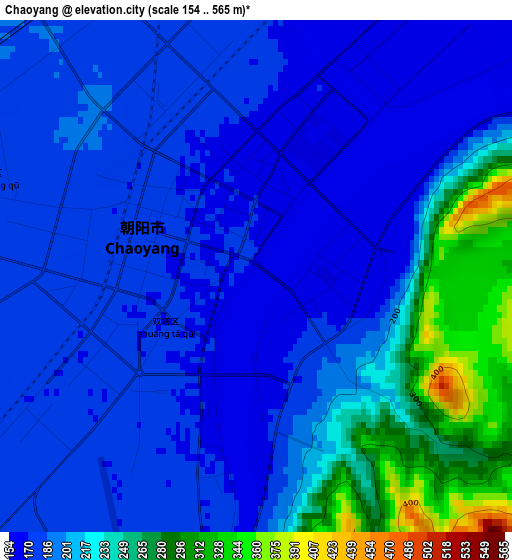
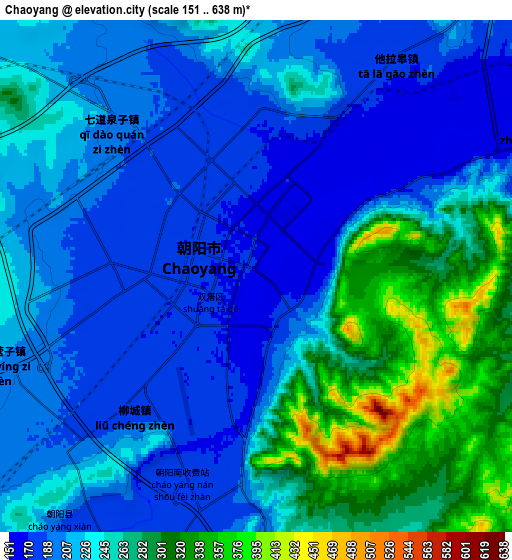
Below is the Elevation map of Chaoyang, which displays elevation range with different colors. Scale of the first map is from 154 to 565 m (505 to 1854 ft) with average elevation of 202.5 meters (=664 ft) [note 1]
These maps also provides idea of topography and contour of this city, they are displayed at different zoom levels. More info about maps, scale and edge coordinates you can find below images.
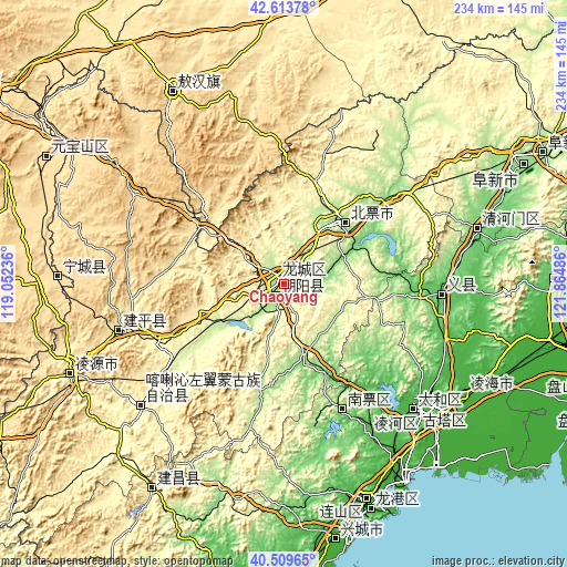
| \ | Map #1 | Map #2 | Topo.Map |
| Scale [m] | 154..565 m | 151..638 m | × |
| Scale [ft] | 505..1854 ft | 495..2093 ft | × |
| Average | 202.5 m = 664 ft | 232.1 m = 761 ft | × |
| Width | 7.31 km = 4.5 mi | 14.62 km = 9.1 mi | 234 km = 145.4 mi |
| Height | 7.31 km = 4.5 mi | 14.62 km = 9.1 mi | 233.9 km = 145.3 mi |
| ↑Max Latitude | 41.603149° | 41.636001° | 42.61378° |
| Latitude at center | 41.57028° | 41.57028° | 41.57028° |
| ↓Min Latitude | 41.537394° | 41.504492° | 40.50965° |
| ← Min Longitude | 120.414665° | 120.370719° | 119.05236° |
| Longitude center | 120.45861° | 120.45861° | 120.45861° |
| →Max Longitude | 120.502555° | 120.546501° | 121.86486° |
Nearby cities:
Cities around Chaoyang sort by population:
• Jinzhou elevation 26 m
76.8 km,  132°
132°
• Lianshan 17 m
95.5 km,  159°
159°
• Nanpiao 98 m
57.8 km, 155°
• Beipiao 266 m
36.3 km,  47°
47°
• Xingcheng 10 m
108.2 km,  168°
168°
• Lingyuan 394 m
95.5 km,  247°
247°
• Yebaishou 412 m
70.8 km, 254°
• Linghai 27 m
88.1 km,  120°
120°
• Longgang 18 m
102.2 km, 157°
• Huludao 17 m
96.3 km, 160°
• Tianyi 582 m
93.6 km,  269°
269°
• Xinhui 574 m
91.9 km,  329°
329°
Multilingual:
 En español:
Chaoyang elevación 162 m.
 En France:
Chaoyang élévation 162 m.
 Auf Deutsch:
Chaoyang höhe über dem Meeresspiegel ist 162 m.

Sources and notes:
- [note 1] Map square and city borders are not equal. Map elevation data is calculated only from area inside that square.
- [src 1] Elevation data from geonames database provided with same terms of usage.
- [src 2] The elevation map of Chaoyang is generated using elevation data from NASA's 3 arcsec (90m) resolution SRTM data.
- [src 3] Base (background) map © OpenStreetMap contributors tiles are generated by Geofabrik and OpenTopoMap.
Copyright & License:
This Chaoyang Elevation Map is licensed under CC BY-SA. You may reuse any part from this page, if you give a proper credit by linking to this URL:
 More info on terms of use page.