Yebaishou elevation
Yebaishou (Liaoning), China elevation is 412 meters and Yebaishou elevation in feet is 1352 ft above sea level [src 1]. Yebaishou is a populated place (feature code) with elevation that is 146 meters (479 ft) smaller than average city elevation in China.
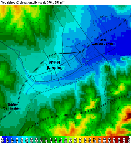
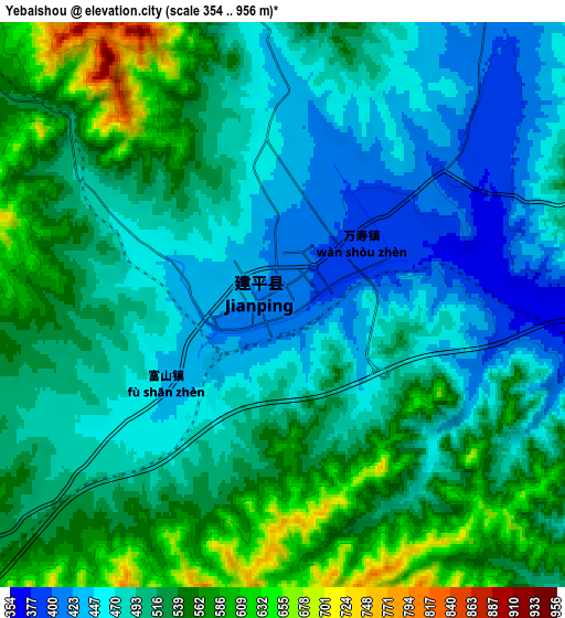
Below is the Elevation map of Yebaishou, which displays elevation range with different colors. Scale of the first map is from 376 to 651 m (1234 to 2136 ft) with average elevation of 450.6 meters (=1478 ft) [note 1]
These maps also provides idea of topography and contour of this city, they are displayed at different zoom levels. More info about maps, scale and edge coordinates you can find below images.
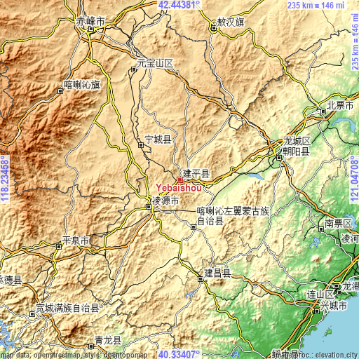
| \ | Map #1 | Map #2 | Topo.Map |
| Scale [m] | 376..651 m | 354..956 m | × |
| Scale [ft] | 1234..2136 ft | 1161..3136 ft | × |
| Average | 450.6 m = 1478 ft | 506.8 m = 1663 ft | × |
| Width | 7.33 km = 4.6 mi | 14.66 km = 9.1 mi | 234.6 km = 145.8 mi |
| Height | 7.33 km = 4.6 mi | 14.66 km = 9.1 mi | 234.6 km = 145.8 mi |
| ↑Max Latitude | 41.430457° | 41.463397° | 42.44381° |
| Latitude at center | 41.3975° | 41.3975° | 41.3975° |
| ↓Min Latitude | 41.364527° | 41.331536° | 40.33407° |
| ← Min Longitude | 119.596885° | 119.552939° | 118.23458° |
| Longitude center | 119.64083° | 119.64083° | 119.64083° |
| →Max Longitude | 119.684775° | 119.728721° | 121.04708° |
Nearby cities:
Cities around Yebaishou sort by population:
• Chaoyang elevation 162 m
70.8 km,  74°
74°
• Chifeng 570 m
111.9 km,  329°
329°
• Nanpiao 98 m
98.4 km,  109°
109°
• Beipiao 266 m
104.3 km, 65°
• Lingyuan 394 m
26.6 km,  228°
228°
• Pingzhuang 514 m
76.9 km,  337°
337°
• Mujiayingzi 687 m
107 km,  318°
318°
• Huludao 17 m
123.2 km,  125°
125°
• Xinhui 574 m
100.8 km,  12°
12°
• Jinshan 894 m
99.4 km,  305°
305°
• Pingquan 499 m
91.3 km,  241°
241°
• Tianyi 582 m
31.8 km, 306°
Multilingual:
 En español:
Yebaishou elevación 412 m.
 En France:
Yebaishou élévation 412 m.
 Auf Deutsch:
Yebaishou höhe über dem Meeresspiegel ist 412 m.

Sources and notes:
- [note 1] Map square and city borders are not equal. Map elevation data is calculated only from area inside that square.
- [src 1] Elevation data from geonames database provided with same terms of usage.
- [src 2] The elevation map of Yebaishou is generated using elevation data from NASA's 3 arcsec (90m) resolution SRTM data.
- [src 3] Base (background) map © OpenStreetMap contributors tiles are generated by Geofabrik and OpenTopoMap.
Copyright & License:
This Yebaishou Elevation Map is licensed under CC BY-SA. You may reuse any part from this page, if you give a proper credit by linking to this URL:
 More info on terms of use page.