Jinshan elevation
Jinshan (Inner Mongolia), China elevation is 894 meters and Jinshan elevation in feet is 2933 ft above sea level [src 1]. Jinshan is a seat of a third-order administrative division (feature code) with elevation that is 336 meters (1102 ft) bigger than average city elevation in China.
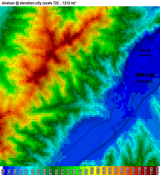
Below is the Elevation map of Jinshan, which displays elevation range with different colors. Scale of the first map is from 722 to 1212 m (2369 to 3976 ft) with average elevation of 898.9 meters (=2949 ft) [note 1]
These maps also provides idea of topography and contour of this city, they are displayed at different zoom levels. More info about maps, scale and edge coordinates you can find below images.
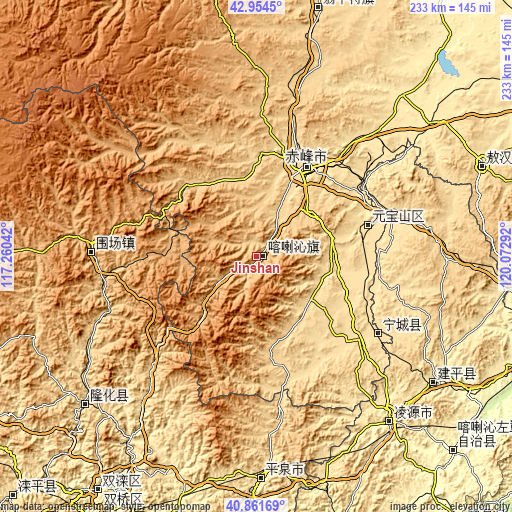
| \ | Map #1 | Topo.Map |
| Scale [m] | 722..1212 m | × |
| Scale [ft] | 2369..3976 ft | × |
| Average | 898.9 m = 2949 ft | × |
| Width | 7.27 km = 4.5 mi | 232.7 km = 144.6 mi |
| Height | 7.27 km = 4.5 mi | 232.7 km = 144.6 mi |
| ↑Max Latitude | 41.949362° | 42.9545° |
| Latitude at center | 41.91667° | 41.91667° |
| ↓Min Latitude | 41.883961° | 40.86169° |
| ← Min Longitude | 118.622725° | 117.26042° |
| Longitude center | 118.66667° | 118.66667° |
| →Max Longitude | 118.710615° | 120.07292° |
Nearby cities:
Cities around Jinshan sort by population:
• Chengde elevation 318 m
122.4 km,  208°
208°
• Chifeng 570 m
46.1 km,  32°
32°
• Lingyuan 394 m
96.9 km,  140°
140°
• Pingzhuang 514 m
53.2 km,  75°
75°
• Yebaishou 412 m
99.4 km,  125°
125°
• Mujiayingzi 687 m
24.2 km,  23°
23°
• Wudan 633 m
116.9 km,  14°
14°
• Xinhui 574 m
109.5 km,  68°
68°
• Longhua 553 m
103.2 km,  229°
229°
• Pingquan 499 m
101.7 km,  179°
179°
• Weichang 887 m
76.1 km,  272°
272°
• Tianyi 582 m
67.6 km, 125°
Multilingual:
 En español:
Jinshan elevación 894 m.
 En France:
Jinshan élévation 894 m.


Sources and notes:
- [note 1] Map square and city borders are not equal. Map elevation data is calculated only from area inside that square.
- [src 1] Elevation data from geonames database provided with same terms of usage.
- [src 2] The elevation map of Jinshan is generated using elevation data from NASA's 3 arcsec (90m) resolution SRTM data.
- [src 3] Base (background) map © OpenStreetMap contributors tiles are generated by Geofabrik and OpenTopoMap.
Copyright & License:
This Jinshan Elevation Map is licensed under CC BY-SA. You may reuse any part from this page, if you give a proper credit by linking to this URL:
 More info on terms of use page.