Jianjun elevation
Jianjun (Shaanxi), China elevation is 982 meters and Jianjun elevation in feet is 3222 ft above sea level [src 1]. Jianjun is a seat of a third-order administrative division (feature code) with elevation that is 424 meters (1391 ft) bigger than average city elevation in China.
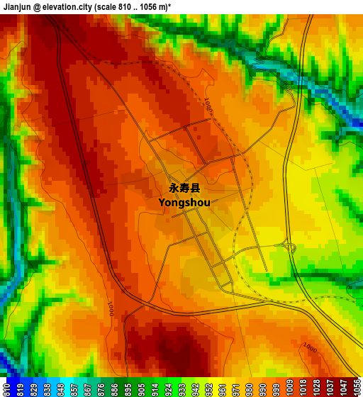
Below is the Elevation map of Jianjun, which displays elevation range with different colors. Scale of the first map is from 810 to 1056 m (2657 to 3465 ft) with average elevation of 976.5 meters (=3204 ft) [note 1]
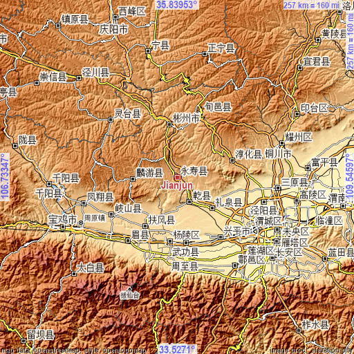
These maps also provides idea of topography and contour of this city, they are displayed at different zoom levels. More info about maps, scale and edge coordinates you can find below images.
| \ | Map #1 | Topo.Map |
| Scale [m] | 810..1056 m | × |
| Scale [ft] | 2657..3465 ft | × |
| Average | 976.5 m = 3204 ft | × |
| Width | 8.04 km = 5 mi | 257.1 km = 159.8 mi |
| Height | 8.04 km = 5 mi | 257.1 km = 159.8 mi |
| ↑Max Latitude | 34.727515° | 35.83953° |
| Latitude at center | 34.69139° | 34.69139° |
| ↓Min Latitude | 34.655249° | 33.5271° |
| ← Min Longitude | 108.095775° | 106.73347° |
| Longitude center | 108.13972° | 108.13972° |
| →Max Longitude | 108.183665° | 109.54597° |
Nearby cities:
Cities around Jianjun sort by population:
• Xianyang elevation 387 m
64.8 km,  127°
127°
• Zhaoren 1196 m
65.5 km,  331°
331°
• Qindu 389 m
65 km, 126°
• Erqu 442 m
60.2 km,  174°
174°
• Shoushan 522 m
58.5 km,  218°
218°
• Fengming 677 m
55.3 km,  239°
239°
• Xunyi Chengguanzhen 1163 m
49.9 km,  18°
18°
• Yangling 460 m
47 km,  186°
186°
• Fufeng 531 m
44.1 km,  213°
213°
• Chunhua 850 m
41.5 km,  73°
73°
• Liquan Chengguanzhen 560 m
35 km, 131°
• Jiuchenggong 1038 m
32.2 km,  267°
267°
Multilingual:
 En español:
Jianjun elevación 982 m.
 En France:
Jianjun élévation 982 m.


Sources and notes:
- [note 1] Map square and city borders are not equal. Map elevation data is calculated only from area inside that square.
- [src 1] Elevation data from geonames database provided with same terms of usage.
- [src 2] The elevation map of Jianjun is generated using elevation data from NASA's 3 arcsec (90m) resolution SRTM data.
- [src 3] Base (background) map © OpenStreetMap contributors tiles are generated by Geofabrik and OpenTopoMap.
Copyright & License:
This Jianjun Elevation Map is licensed under CC BY-SA. You may reuse any part from this page, if you give a proper credit by linking to this URL:
 More info on terms of use page.