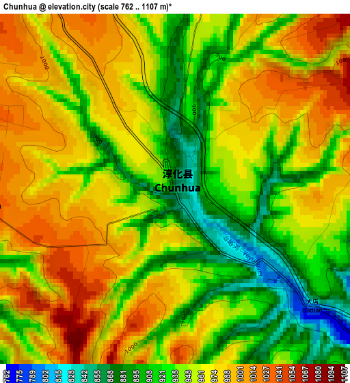
Chunhua elevation
Chunhua (Shaanxi), China elevation is 850 meters and Chunhua elevation in feet is 2789 ft above sea level [src 1]. Chunhua is a seat of a third-order administrative division (feature code) with elevation that is 292 meters (958 ft) bigger than average city elevation in China.
Below is the Elevation map of Chunhua, which displays elevation range with different colors. Scale of the first map is from 762 to 1107 m (2500 to 3632 ft) with average elevation of 955 meters (=3133 ft) [note 1]
These maps also provides idea of topography and contour of this city, they are displayed at different zoom levels. More info about maps, scale and edge coordinates you can find below images.
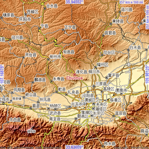
| \ | Map #1 | Topo.Map |
| Scale [m] | 762..1107 m | × |
| Scale [ft] | 2500..3632 ft | × |
| Average | 955 m = 3133 ft | × |
| Width | 8.02 km = 5 mi | 256.8 km = 159.6 mi |
| Height | 8.02 km = 5 mi | 256.8 km = 159.6 mi |
| ↑Max Latitude | 34.834968° | 35.94552° |
| Latitude at center | 34.79889° | 34.79889° |
| ↓Min Latitude | 34.762796° | 33.63609° |
| ← Min Longitude | 108.531055° | 107.16875° |
| Longitude center | 108.575° | 108.575° |
| →Max Longitude | 108.618945° | 109.98125° |
Nearby cities:
Cities around Chunhua sort by population:
• Xianyang elevation 387 m
52.6 km,  167°
167°
• Doucun 445 m
55.5 km,  95°
95°
• Luyuan 380 m
55.1 km,  122°
122°
• Weicheng 383 m
53.6 km, 165°
• Qindu 389 m
52.3 km, 166°
• Xunyi Chengguanzhen 1163 m
42.7 km,  325°
325°
• Jianjun 982 m
41.5 km,  253°
253°
• Jinggan 409 m
38.2 km,  141°
141°
• Sanyuan Chengguanzhen 425 m
38.2 km, 122°
• Liquan Chengguanzhen 560 m
38 km,  201°
201°
• Yaozhou 627 m
37.9 km,  71°
71°
• Tongchuan 711 m
36 km, 72°
Multilingual:
 En español:
Chunhua elevación 850 m.
 En France:
Chunhua élévation 850 m.


Sources and notes:
- [note 1] Map square and city borders are not equal. Map elevation data is calculated only from area inside that square.
- [src 1] Elevation data from geonames database provided with same terms of usage.
- [src 2] The elevation map of Chunhua is generated using elevation data from NASA's 3 arcsec (90m) resolution SRTM data.
- [src 3] Base (background) map © OpenStreetMap contributors tiles are generated by Geofabrik and OpenTopoMap.
Copyright & License:
This Chunhua Elevation Map is licensed under CC BY-SA. You may reuse any part from this page, if you give a proper credit by linking to this URL:
 More info on terms of use page.