Yangling elevation
Yangling (Shaanxi), China elevation is 460 meters and Yangling elevation in feet is 1509 ft above sea level [src 1]. Yangling is a seat of a third-order administrative division (feature code) with elevation that is 98 meters (322 ft) smaller than average city elevation in China.
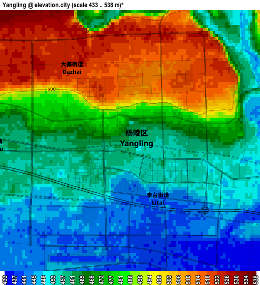
Below is the Elevation map of Yangling, which displays elevation range with different colors. Scale of the first map is from 433 to 538 m (1421 to 1765 ft) with average elevation of 472.9 meters (=1552 ft) [note 1]
These maps also provides idea of topography and contour of this city, they are displayed at different zoom levels. More info about maps, scale and edge coordinates you can find below images.
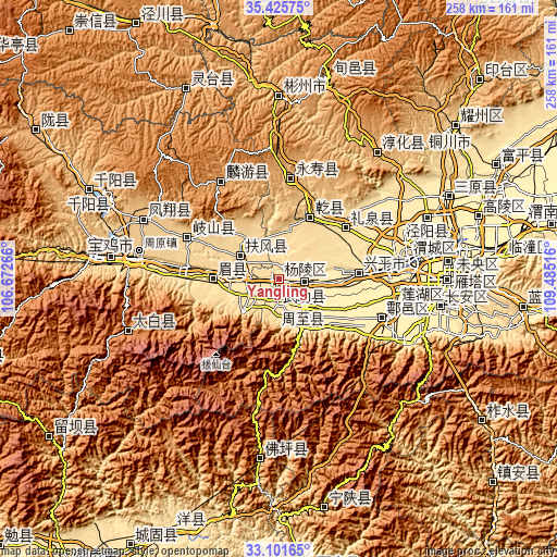
| \ | Map #1 | Topo.Map |
| Scale [m] | 433..538 m | × |
| Scale [ft] | 1421..1765 ft | × |
| Average | 472.9 m = 1552 ft | × |
| Width | 8.08 km = 5 mi | 258.4 km = 160.6 mi |
| Height | 8.08 km = 5 mi | 258.4 km = 160.6 mi |
| ↑Max Latitude | 34.308038° | 35.42575° |
| Latitude at center | 34.27173° | 34.27173° |
| ↓Min Latitude | 34.235407° | 33.10165° |
| ← Min Longitude | 108.034965° | 106.67266° |
| Longitude center | 108.07891° | 108.07891° |
| →Max Longitude | 108.122855° | 109.48516° |
Nearby cities:
Cities around Yangling sort by population:
• Xianyang elevation 387 m
57.8 km,  82°
82°
• Yuxia 428 m
55.7 km,  114°
114°
• Weicheng 383 m
59 km, 83°
• Qindu 389 m
58.3 km, 82°
• Ganting 414 m
52.7 km, 110°
• Jiuchenggong 1038 m
52.5 km,  329°
329°
• Jianjun 982 m
47 km,  6°
6°
• Fengming 677 m
46.3 km,  294°
294°
• Liquan Chengguanzhen 560 m
39.3 km,  53°
53°
• Shoushan 522 m
30.6 km,  271°
271°
• Fufeng 531 m
21.3 km,  297°
297°
• Erqu 442 m
17.7 km,  138°
138°
Multilingual:
 En español:
Yangling elevación 460 m.
 En France:
Yangling élévation 460 m.
 Auf Deutsch:
Yangling höhe über dem Meeresspiegel ist 460 m.

Sources and notes:
- [note 1] Map square and city borders are not equal. Map elevation data is calculated only from area inside that square.
- [src 1] Elevation data from geonames database provided with same terms of usage.
- [src 2] The elevation map of Yangling is generated using elevation data from NASA's 3 arcsec (90m) resolution SRTM data.
- [src 3] Base (background) map © OpenStreetMap contributors tiles are generated by Geofabrik and OpenTopoMap.
Copyright & License:
This Yangling Elevation Map is licensed under CC BY-SA. You may reuse any part from this page, if you give a proper credit by linking to this URL:
 More info on terms of use page.