Tangjiafang elevation
Tangjiafang (Hunan), China elevation is 466 meters and Tangjiafang elevation in feet is 1529 ft above sea level [src 1]. Tangjiafang is a populated place (feature code) with elevation that is 92 meters (302 ft) smaller than average city elevation in China.
Below is the Elevation map of Tangjiafang, which displays elevation range with different colors. Scale of the first map is from 408 to 921 m (1339 to 3022 ft) with average elevation of 528.6 meters (=1734 ft) [note 1]
These maps also provides idea of topography and contour of this city, they are displayed at different zoom levels. More info about maps, scale and edge coordinates you can find below images.
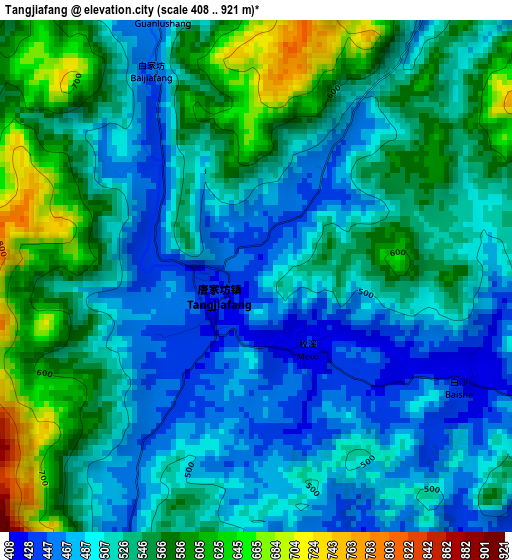
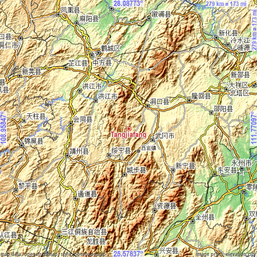
| \ | Map #1 | Topo.Map |
| Scale [m] | 408..921 m | × |
| Scale [ft] | 1339..3022 ft | × |
| Average | 528.6 m = 1734 ft | × |
| Width | 8.72 km = 5.4 mi | 279 km = 173.4 mi |
| Height | 8.72 km = 5.4 mi | 279 km = 173.4 mi |
| ↑Max Latitude | 26.879204° | 28.08773° |
| Latitude at center | 26.84° | 26.84° |
| ↓Min Latitude | 26.800782° | 25.57837° |
| ← Min Longitude | 110.320775° | 108.95847° |
| Longitude center | 110.36472° | 110.36472° |
| →Max Longitude | 110.408665° | 111.77097° |
Nearby cities:
Cities around Tangjiafang sort by population:
• Xiyan elevation 391 m
27.1 km,  156°
156°
• Maoping 502 m
35.9 km,  172°
172°
• Wuyang 464 m
11.4 km,  198°
198°
• Dengyuantai 356 m
24.4 km,  133°
133°
• Huangtukuang 427 m
9.4 km,  27°
27°
• Lixiqiao 414 m
7.3 km, 133°
• Wantouqiao 331 m
25.3 km,  89°
89°
• Huayuan 343 m
18.8 km,  64°
64°
• Zhuzhoujiang Miaozuxiang 351 m
34.4 km,  237°
237°
• Jiangfang 447 m
37.7 km,  182°
182°
• Gaoyi 290 m
37.1 km,  290°
290°
• Dongkou 403 m
29.1 km,  35°
35°
Multilingual:
 En español:
Tangjiafang elevación 466 m.
 En France:
Tangjiafang élévation 466 m.
 Auf Deutsch:
Tangjiafang höhe über dem Meeresspiegel ist 466 m.

Sources and notes:
- [note 1] Map square and city borders are not equal. Map elevation data is calculated only from area inside that square.
- [src 1] Elevation data from geonames database provided with same terms of usage.
- [src 2] The elevation map of Tangjiafang is generated using elevation data from NASA's 3 arcsec (90m) resolution SRTM data.
- [src 3] Base (background) map © OpenStreetMap contributors tiles are generated by Geofabrik and OpenTopoMap.
Copyright & License:
This Tangjiafang Elevation Map is licensed under CC BY-SA. You may reuse any part from this page, if you give a proper credit by linking to this URL:
 More info on terms of use page.