Maoping elevation
Maoping (Hunan), China elevation is 502 meters and Maoping elevation in feet is 1647 ft above sea level [src 1]. Maoping is a populated place (feature code) with elevation that is 56 meters (184 ft) smaller than average city elevation in China.
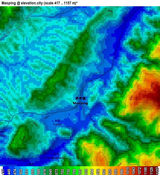
Below is the Elevation map of Maoping, which displays elevation range with different colors. Scale of the first map is from 417 to 1157 m (1368 to 3796 ft) with average elevation of 601.8 meters (=1974 ft) [note 1]
These maps also provides idea of topography and contour of this city, they are displayed at different zoom levels. More info about maps, scale and edge coordinates you can find below images.
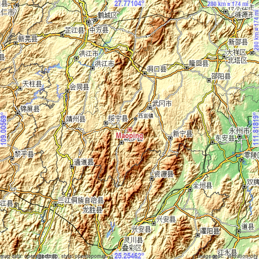
| \ | Map #1 | Topo.Map |
| Scale [m] | 417..1157 m | × |
| Scale [ft] | 1368..3796 ft | × |
| Average | 601.8 m = 1974 ft | × |
| Width | 8.74 km = 5.4 mi | 279.8 km = 173.9 mi |
| Height | 8.74 km = 5.4 mi | 279.8 km = 173.9 mi |
| ↑Max Latitude | 26.559035° | 27.77104° |
| Latitude at center | 26.51972° | 26.51972° |
| ↓Min Latitude | 26.480392° | 25.25462° |
| ← Min Longitude | 110.367995° | 109.00569° |
| Longitude center | 110.41194° | 110.41194° |
| →Max Longitude | 110.455885° | 111.81819° |
Nearby cities:
Cities around Maoping sort by population:
• Zhaishi Miaozu Dongzuxiang elevation 442 m
36.6 km,  266°
266°
• Xiyan 391 m
12.4 km,  29°
29°
• Wuyang 464 m
26.2 km,  341°
341°
• Dengyuantai 356 m
22.8 km, 34°
• Malin 846 m
24 km,  107°
107°
• Lixiqiao 414 m
30.6 km,  1°
1°
• Qingxi 437 m
11.4 km,  209°
209°
• Tangjiafang 466 m
35.9 km,  352°
352°
• Zhuzhoujiang Miaozuxiang 351 m
38 km,  297°
297°
• Jiangfang 447 m
6.8 km,  252°
252°
• Changpu 462 m
30.9 km,  281°
281°
• Rulin 637 m
24.1 km,  217°
217°
Multilingual:
 En español:
Maoping elevación 502 m.
 En France:
Maoping élévation 502 m.


Sources and notes:
- [note 1] Map square and city borders are not equal. Map elevation data is calculated only from area inside that square.
- [src 1] Elevation data from geonames database provided with same terms of usage.
- [src 2] The elevation map of Maoping is generated using elevation data from NASA's 3 arcsec (90m) resolution SRTM data.
- [src 3] Base (background) map © OpenStreetMap contributors tiles are generated by Geofabrik and OpenTopoMap.
Copyright & License:
This Maoping Elevation Map is licensed under CC BY-SA. You may reuse any part from this page, if you give a proper credit by linking to this URL:
 More info on terms of use page.