Dongkou elevation
Dongkou (Hunan), China elevation is 403 meters and Dongkou elevation in feet is 1322 ft above sea level [src 1]. Dongkou is a seat of a third-order administrative division (feature code) with elevation that is 155 meters (509 ft) smaller than average city elevation in China.
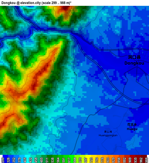
Below is the Elevation map of Dongkou, which displays elevation range with different colors. Scale of the first map is from 299 to 988 m (981 to 3241 ft) with average elevation of 441.9 meters (=1450 ft) [note 1]
These maps also provides idea of topography and contour of this city, they are displayed at different zoom levels. More info about maps, scale and edge coordinates you can find below images.
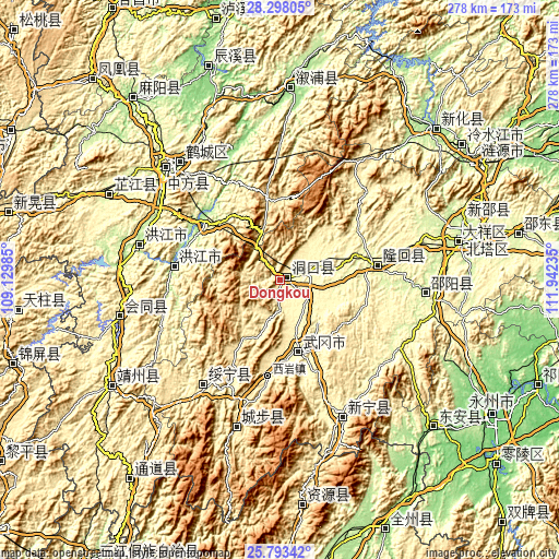
| \ | Map #1 | Topo.Map |
| Scale [m] | 299..988 m | × |
| Scale [ft] | 981..3241 ft | × |
| Average | 441.9 m = 1450 ft | × |
| Width | 8.7 km = 5.4 mi | 278.5 km = 173.1 mi |
| Height | 8.7 km = 5.4 mi | 278.5 km = 173.1 mi |
| ↑Max Latitude | 27.09185° | 28.29805° |
| Latitude at center | 27.05272° | 27.05272° |
| ↓Min Latitude | 27.013576° | 25.79342° |
| ← Min Longitude | 110.492155° | 109.12985° |
| Longitude center | 110.5361° | 110.5361° |
| →Max Longitude | 110.580045° | 111.94235° |
Nearby cities:
Cities around Dongkou sort by population:
• Shijiang elevation 277 m
25.7 km,  82°
82°
• Shanmen 348 m
24.6 km,  38°
38°
• Huangqiao 265 m
30.3 km,  96°
96°
• Zhushi 289 m
14.5 km,  74°
74°
• Huangtukuang 427 m
19.9 km,  219°
219°
• Lixiqiao 414 m
31 km,  202°
202°
• Huangmaoyuan 561 m
39.5 km,  351°
351°
• Wantouqiao 331 m
24.9 km,  160°
160°
• Hengbanqiao 294 m
35.2 km, 67°
• Huayuan 343 m
15.5 km,  180°
180°
• Ma’an 295 m
20.1 km,  114°
114°
• Tangjiafang 466 m
29.1 km, 215°
Multilingual:
 En español:
Dongkou elevación 403 m.
 En France:
Dongkou élévation 403 m.


Sources and notes:
- [note 1] Map square and city borders are not equal. Map elevation data is calculated only from area inside that square.
- [src 1] Elevation data from geonames database provided with same terms of usage.
- [src 2] The elevation map of Dongkou is generated using elevation data from NASA's 3 arcsec (90m) resolution SRTM data.
- [src 3] Base (background) map © OpenStreetMap contributors tiles are generated by Geofabrik and OpenTopoMap.
Copyright & License:
This Dongkou Elevation Map is licensed under CC BY-SA. You may reuse any part from this page, if you give a proper credit by linking to this URL:
 More info on terms of use page.