Gaoyi elevation
Gaoyi (Hunan), China elevation is 290 meters and Gaoyi elevation in feet is 951 ft above sea level [src 1]. Gaoyi is a populated place (feature code) with elevation that is 268 meters (879 ft) smaller than average city elevation in China.
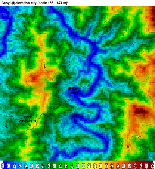
Below is the Elevation map of Gaoyi, which displays elevation range with different colors. Scale of the first map is from 186 to 674 m (610 to 2211 ft) with average elevation of 352.8 meters (=1157 ft) [note 1]
These maps also provides idea of topography and contour of this city, they are displayed at different zoom levels. More info about maps, scale and edge coordinates you can find below images.
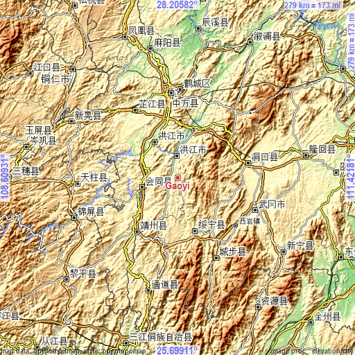
| \ | Map #1 | Topo.Map |
| Scale [m] | 186..674 m | × |
| Scale [ft] | 610..2211 ft | × |
| Average | 352.8 m = 1157 ft | × |
| Width | 8.71 km = 5.4 mi | 278.7 km = 173.2 mi |
| Height | 8.71 km = 5.4 mi | 278.7 km = 173.2 mi |
| ↑Max Latitude | 26.998603° | 28.20582° |
| Latitude at center | 26.95944° | 26.95944° |
| ↓Min Latitude | 26.920264° | 25.69911° |
| ← Min Longitude | 109.971615° | 108.60931° |
| Longitude center | 110.01556° | 110.01556° |
| →Max Longitude | 110.059505° | 111.42181° |
Nearby cities:
Cities around Gaoyi sort by population:
• Hongjiang elevation 197 m
16.9 km,  353°
353°
• Anjiang 196 m
41 km,  12°
12°
• Qiancheng 214 m
35.2 km,  315°
315°
• Wuyang 464 m
39.3 km,  127°
127°
• Huangtukuang 427 m
39.2 km,  97°
97°
• Jiangshi 197 m
33 km,  303°
303°
• Tangjiafang 466 m
37.1 km,  110°
110°
• Puzi 323 m
23.9 km,  277°
277°
• Zhuzhoujiang Miaozuxiang 351 m
32.1 km,  169°
169°
• Ruoshui 202 m
6.8 km,  314°
314°
• Shuangxi 238 m
33.8 km,  332°
332°
• Lincheng 263 m
36.3 km,  253°
253°
Multilingual:
 En español:
Gaoyi elevación 290 m.
 En France:
Gaoyi élévation 290 m.


Sources and notes:
- [note 1] Map square and city borders are not equal. Map elevation data is calculated only from area inside that square.
- [src 1] Elevation data from geonames database provided with same terms of usage.
- [src 2] The elevation map of Gaoyi is generated using elevation data from NASA's 3 arcsec (90m) resolution SRTM data.
- [src 3] Base (background) map © OpenStreetMap contributors tiles are generated by Geofabrik and OpenTopoMap.
Copyright & License:
This Gaoyi Elevation Map is licensed under CC BY-SA. You may reuse any part from this page, if you give a proper credit by linking to this URL:
 More info on terms of use page.