Qiancheng elevation
Qiancheng (Hunan), China elevation is 214 meters and Qiancheng elevation in feet is 702 ft above sea level [src 1]. Qiancheng is a seat of a third-order administrative division (feature code) with elevation that is 344 meters (1129 ft) smaller than average city elevation in China.
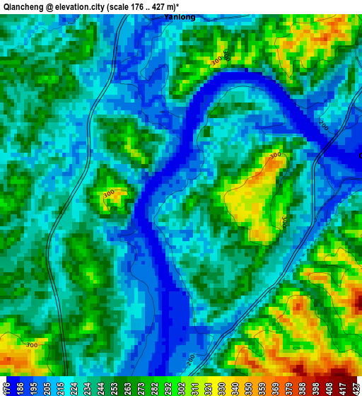
Below is the Elevation map of Qiancheng, which displays elevation range with different colors. Scale of the first map is from 176 to 427 m (577 to 1401 ft) with average elevation of 244.8 meters (=803 ft) [note 1]
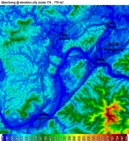
These maps also provides idea of topography and contour of this city, they are displayed at different zoom levels. More info about maps, scale and edge coordinates you can find below images.
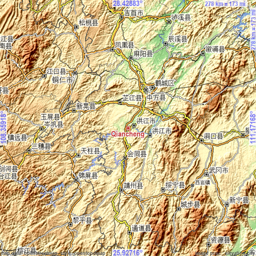
| \ | Map #1 | Map #2 | Topo.Map |
| Scale [m] | 176..427 m | 174..770 m | × |
| Scale [ft] | 577..1401 ft | 571..2526 ft | × |
| Average | 244.8 m = 803 ft | 273 m = 896 ft | × |
| Width | 8.69 km = 5.4 mi | 17.39 km = 10.8 mi | 278.2 km = 172.9 mi |
| Height | 8.69 km = 5.4 mi | 17.39 km = 10.8 mi | 278.2 km = 172.9 mi |
| ↑Max Latitude | 27.224094° | 27.263164° | 28.42883° |
| Latitude at center | 27.18501° | 27.18501° | 27.18501° |
| ↓Min Latitude | 27.145912° | 27.106801° | 25.92716° |
| ← Min Longitude | 109.721485° | 109.677539° | 108.35918° |
| Longitude center | 109.76543° | 109.76543° | 109.76543° |
| →Max Longitude | 109.809375° | 109.853321° | 111.17168° |
Nearby cities:
Cities around Qiancheng sort by population:
• Hongjiang elevation 197 m
24.2 km,  110°
110°
• Tuokou 221 m
15.5 km,  244°
244°
• Jiangshi 197 m
7.4 km,  201°
201°
• Puzi 323 m
22.1 km,  177°
177°
• Biyong 284 m
25.3 km,  270°
270°
• Zhongfang 208 m
30.1 km,  33°
33°
• Nanmuping 359 m
16.4 km,  328°
328°
• Ruoshui 202 m
28.5 km,  135°
135°
• Gaoyi 290 m
35.2 km, 135°
• Shuangxi 238 m
10.2 km,  61°
61°
• Lincheng 263 m
36.5 km, 196°
• Zhijiang 267 m
32.1 km,  340°
340°
Multilingual:
 En español:
Qiancheng elevación 214 m.
 En France:
Qiancheng élévation 214 m.
 Auf Deutsch:
Qiancheng höhe über dem Meeresspiegel ist 214 m.

Sources and notes:
- [note 1] Map square and city borders are not equal. Map elevation data is calculated only from area inside that square.
- [src 1] Elevation data from geonames database provided with same terms of usage.
- [src 2] The elevation map of Qiancheng is generated using elevation data from NASA's 3 arcsec (90m) resolution SRTM data.
- [src 3] Base (background) map © OpenStreetMap contributors tiles are generated by Geofabrik and OpenTopoMap.
Copyright & License:
This Qiancheng Elevation Map is licensed under CC BY-SA. You may reuse any part from this page, if you give a proper credit by linking to this URL:
 More info on terms of use page.