Lodja elevation
Lodja (Sankuru), Democratic Republic of the Congo elevation is 478 meters and Lodja elevation in feet is 1568 ft above sea level [src 1]. Lodja is a populated place (feature code) with elevation that is 178 meters (584 ft) smaller than average city elevation in Democratic Republic of the Congo.
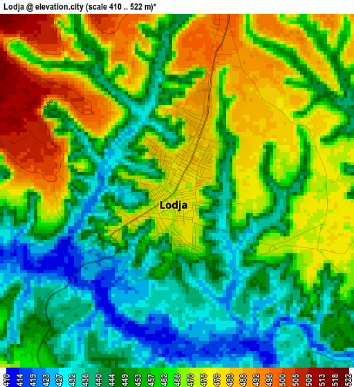
Below is the Elevation map of Lodja, which displays elevation range with different colors. Scale of the first map is from 410 to 522 m (1345 to 1713 ft) with average elevation of 458.3 meters (=1504 ft) [note 1]
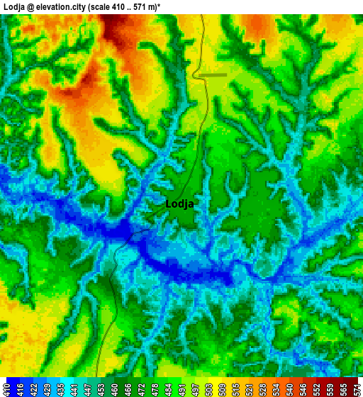
These maps also provides idea of topography and contour of this city, they are displayed at different zoom levels. More info about maps, scale and edge coordinates you can find below images.
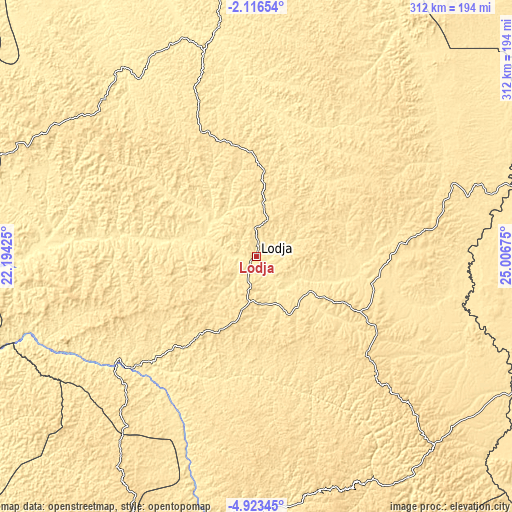
| \ | Map #1 | Map #2 | Topo.Map |
| Scale [m] | 410..522 m | 410..571 m | × |
| Scale [ft] | 1345..1713 ft | 1345..1873 ft | × |
| Average | 458.3 m = 1504 ft | 471.1 m = 1546 ft | × |
| Width | 9.75 km = 6.1 mi | 19.51 km = 12.1 mi | 312.1 km = 193.9 mi |
| Height | 9.75 km = 6.1 mi | 19.51 km = 12.1 mi | 312.1 km = 193.9 mi |
| ↑Max Latitude | -3.477187° | -3.433321° | -2.11654° |
| Latitude at center | -3.52105° | -3.52105° | -3.52105° |
| ↓Min Latitude | -3.564911° | -3.608771° | -4.92345° |
| ← Min Longitude | 23.556555° | 23.512609° | 22.19425° |
| Longitude center | 23.6005° | 23.6005° | 23.6005° |
| →Max Longitude | 23.644445° | 23.688391° | 25.00675° |
Nearby cities:
Cities around Lodja sort by population:
• Mbuji-Mayi elevation 621 m
290.8 km,  180°
180°
• Kananga 643 m
294.9 km,  206°
206°
• Kindu 464 m
265.6 km,  76°
76°
• Ilebo 440 m
346.3 km,  254°
254°
• Kabinda 884 m
306.9 km,  161°
161°
• Kasongo 640 m
354.7 km,  106°
106°
• Mweka 591 m
270.4 km,  236°
236°
• Lubao 694 m
315.9 km,  131°
131°
• Lusambo 432 m
162.6 km,  186°
186°
• Kampene 652 m
340.4 km,  91°
91°
• Luebo 498 m
315.9 km,  229°
229°
• Demba 632 m
264.5 km, 213°
Multilingual:
 En español:
Lodja elevación 478 m.
 En France:
Lodja élévation 478 m.


Sources and notes:
- [note 1] Map square and city borders are not equal. Map elevation data is calculated only from area inside that square.
- [src 1] Elevation data from geonames database provided with same terms of usage.
- [src 2] The elevation map of Lodja is generated using elevation data from NASA's 3 arcsec (90m) resolution SRTM data.
- [src 3] Base (background) map © OpenStreetMap contributors tiles are generated by Geofabrik and OpenTopoMap.
Copyright & License:
This Lodja Elevation Map is licensed under CC BY-SA. You may reuse any part from this page, if you give a proper credit by linking to this URL:
 More info on terms of use page.