Mbuji-Mayi elevation
Mbuji-Mayi (Kasaï-Oriental), Democratic Republic of the Congo elevation is 621 meters and Mbuji-Mayi elevation in feet is 2037 ft above sea level [src 1]. Mbuji-Mayi is a seat of a first-order administrative division (feature code) with elevation that is 35 meters (115 ft) smaller than average city elevation in Democratic Republic of the Congo.
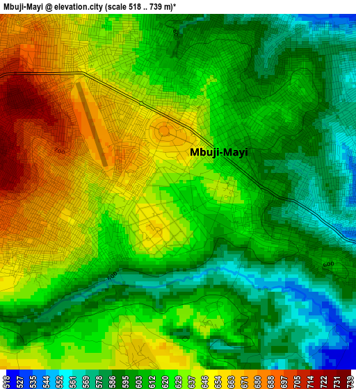
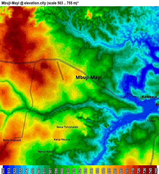
Below is the Elevation map of Mbuji-Mayi, which displays elevation range with different colors. Scale of the first map is from 518 to 739 m (1699 to 2425 ft) with average elevation of 620.1 meters (=2034 ft) [note 1]
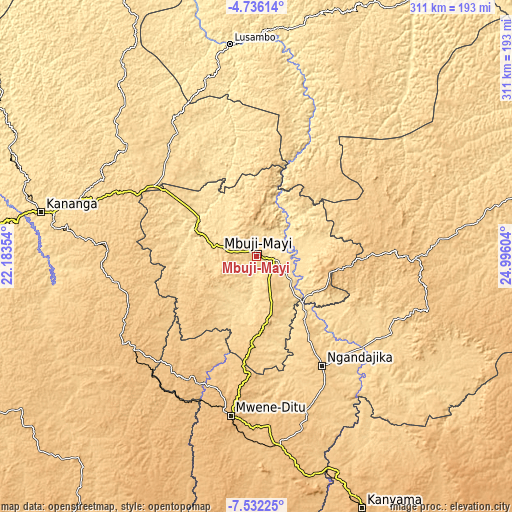
These maps also provides idea of topography and contour of this city, they are displayed at different zoom levels. More info about maps, scale and edge coordinates you can find below images.
| \ | Map #1 | Map #2 | Topo.Map |
| Scale [m] | 518..739 m | 503..755 m | × |
| Scale [ft] | 1699..2425 ft | 1650..2477 ft | × |
| Average | 620.1 m = 2034 ft | 614.5 m = 2016 ft | × |
| Width | 9.72 km = 6 mi | 19.43 km = 12.1 mi | 310.9 km = 193.2 mi |
| Height | 9.72 km = 6 mi | 19.43 km = 12.1 mi | 310.9 km = 193.2 mi |
| ↑Max Latitude | -6.092335° | -6.048636° | -4.73614° |
| Latitude at center | -6.13603° | -6.13603° | -6.13603° |
| ↓Min Latitude | -6.179722° | -6.22341° | -7.53225° |
| ← Min Longitude | 23.545845° | 23.501899° | 22.18354° |
| Longitude center | 23.58979° | 23.58979° | 23.58979° |
| →Max Longitude | 23.633735° | 23.677681° | 24.99604° |
Nearby cities:
Cities around Mbuji-Mayi sort by population:
• Kananga elevation 643 m
132.4 km,  281°
281°
• Tshikapa 484 m
309.9 km,  264°
264°
• Mwene-Ditu 970 m
98.2 km,  188°
188°
• Gandajika 802 m
78.7 km,  149°
149°
• Kamina 1124 m
328 km, 151°
• Lodja 478 m
290.8 km,  0°
0°
• Kabinda 884 m
98.6 km,  90°
90°
• Mweka 591 m
266.2 km,  302°
302°
• Lubao 694 m
252.9 km,  70°
70°
• Lusambo 432 m
130.1 km,  352°
352°
• Luebo 498 m
255.2 km,  289°
289°
• Demba 632 m
162.5 km, 295°
Multilingual:
 En español:
Mbuji-Mayi elevación 621 m.
 En France:
Mbuji-Mayi élévation 621 m.
 Auf Deutsch:
Mbuji-Mayi höhe über dem Meeresspiegel ist 621 m.

Sources and notes:
- [note 1] Map square and city borders are not equal. Map elevation data is calculated only from area inside that square.
- [src 1] Elevation data from geonames database provided with same terms of usage.
- [src 2] The elevation map of Mbuji-Mayi is generated using elevation data from NASA's 3 arcsec (90m) resolution SRTM data.
- [src 3] Base (background) map © OpenStreetMap contributors tiles are generated by Geofabrik and OpenTopoMap.
Copyright & License:
This Mbuji-Mayi Elevation Map is licensed under CC BY-SA. You may reuse any part from this page, if you give a proper credit by linking to this URL:
 More info on terms of use page.