Kindu elevation
Kindu (Maniema), Democratic Republic of the Congo elevation is 464 meters and Kindu elevation in feet is 1522 ft above sea level [src 1]. Kindu is a seat of a first-order administrative division (feature code) with elevation that is 192 meters (630 ft) smaller than average city elevation in Democratic Republic of the Congo.
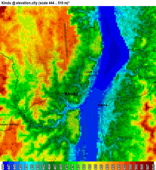
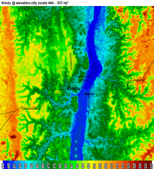
Below is the Elevation map of Kindu, which displays elevation range with different colors. Scale of the first map is from 444 to 510 m (1457 to 1673 ft) with average elevation of 472.3 meters (=1550 ft) [note 1]
These maps also provides idea of topography and contour of this city, they are displayed at different zoom levels. More info about maps, scale and edge coordinates you can find below images.
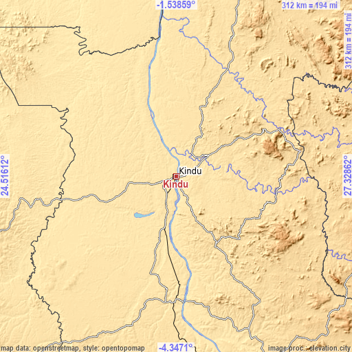
| \ | Map #1 | Map #2 | Topo.Map |
| Scale [m] | 444..510 m | 444..537 m | × |
| Scale [ft] | 1457..1673 ft | 1457..1762 ft | × |
| Average | 472.3 m = 1550 ft | 483.8 m = 1587 ft | × |
| Width | 9.76 km = 6.1 mi | 19.52 km = 12.1 mi | 312.3 km = 194.1 mi |
| Height | 9.76 km = 6.1 mi | 19.52 km = 12.1 mi | 312.3 km = 194.1 mi |
| ↑Max Latitude | -2.899842° | -2.855952° | -1.53859° |
| Latitude at center | -2.94373° | -2.94373° | -2.94373° |
| ↓Min Latitude | -2.987616° | -3.031501° | -4.3471° |
| ← Min Longitude | 25.878425° | 25.834479° | 24.51612° |
| Longitude center | 25.92237° | 25.92237° | 25.92237° |
| →Max Longitude | 25.966315° | 26.010261° | 27.32862° |
Nearby cities:
Cities around Kindu sort by population:
• Bukavu elevation 1631 m
328.2 km,  81°
81°
• Uvira 806 m
360.5 km,  98°
98°
• Lodja 478 m
265.6 km,  256°
256°
• Kabinda 884 m
389.4 km,  204°
204°
• Kasongo 640 m
184.5 km,  153°
153°
• Lubao 694 m
272.4 km,  184°
184°
• Lusambo 432 m
355.8 km,  230°
230°
• Kabare 1996 m
322.4 km, 81°
• Kampene 652 m
110 km,  131°
131°
• Kongolo 562 m
296.6 km,  156°
156°
• Kabalo 560 m
362.7 km, 162°
• Sake 1468 m
378.7 km,  66°
66°
Multilingual:
 En español:
Kindu elevación 464 m.
 En France:
Kindu élévation 464 m.


Sources and notes:
- [note 1] Map square and city borders are not equal. Map elevation data is calculated only from area inside that square.
- [src 1] Elevation data from geonames database provided with same terms of usage.
- [src 2] The elevation map of Kindu is generated using elevation data from NASA's 3 arcsec (90m) resolution SRTM data.
- [src 3] Base (background) map © OpenStreetMap contributors tiles are generated by Geofabrik and OpenTopoMap.
Copyright & License:
This Kindu Elevation Map is licensed under CC BY-SA. You may reuse any part from this page, if you give a proper credit by linking to this URL:
 More info on terms of use page.