Kongolo elevation
Kongolo (Tanganyika), Democratic Republic of the Congo elevation is 562 meters and Kongolo elevation in feet is 1844 ft above sea level [src 1]. Kongolo is a populated place (feature code) with elevation that is 94 meters (308 ft) smaller than average city elevation in Democratic Republic of the Congo.
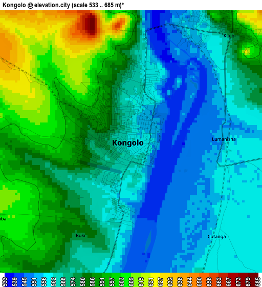
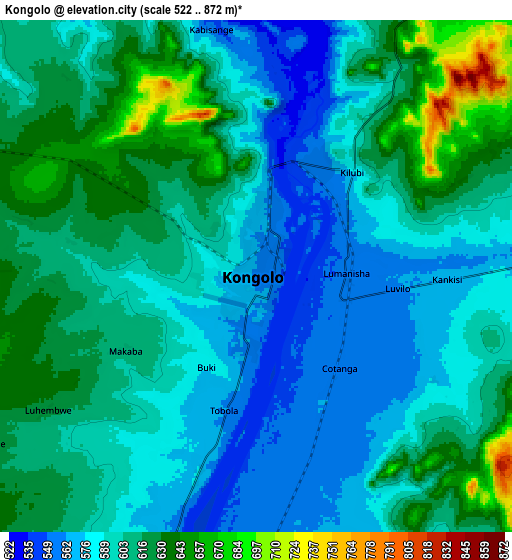
Below is the Elevation map of Kongolo, which displays elevation range with different colors. Scale of the first map is from 533 to 685 m (1749 to 2247 ft) with average elevation of 575.8 meters (=1889 ft) [note 1]
These maps also provides idea of topography and contour of this city, they are displayed at different zoom levels. More info about maps, scale and edge coordinates you can find below images.
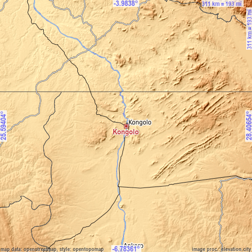
| \ | Map #1 | Map #2 | Topo.Map |
| Scale [m] | 533..685 m | 522..872 m | × |
| Scale [ft] | 1749..2247 ft | 1713..2861 ft | × |
| Average | 575.8 m = 1889 ft | 602.3 m = 1976 ft | × |
| Width | 9.73 km = 6 mi | 19.46 km = 12.1 mi | 311.3 km = 193.4 mi |
| Height | 9.73 km = 6 mi | 19.46 km = 12.1 mi | 311.3 km = 193.4 mi |
| ↑Max Latitude | -5.341567° | -5.297811° | -3.9838° |
| Latitude at center | -5.38532° | -5.38532° | -5.38532° |
| ↓Min Latitude | -5.42907° | -5.472816° | -6.78361° |
| ← Min Longitude | 26.956345° | 26.912399° | 25.59404° |
| Longitude center | 27.00029° | 27.00029° | 27.00029° |
| →Max Longitude | 27.044235° | 27.088181° | 28.40654° |
Nearby cities:
Cities around Kongolo sort by population:
• Mbuji-Mayi elevation 621 m
386.4 km,  257°
257°
• Bukavu 1631 m
381.2 km,  32°
32°
• Uvira 806 m
324.2 km,  46°
46°
• Gandajika 802 m
369.3 km,  245°
245°
• Kalemie 787 m
250.7 km,  104°
104°
• Kindu 464 m
296.6 km,  336°
336°
• Kabinda 884 m
290.9 km, 253°
• Kasongo 640 m
112.7 km, 340°
• Lubao 694 m
138.5 km,  269°
269°
• Kabare 1996 m
377.6 km, 31°
• Kampene 652 m
202.3 km,  349°
349°
• Kabalo 560 m
74.8 km,  187°
187°
Multilingual:
 En español:
Kongolo elevación 562 m.
 En France:
Kongolo élévation 562 m.


Sources and notes:
- [note 1] Map square and city borders are not equal. Map elevation data is calculated only from area inside that square.
- [src 1] Elevation data from geonames database provided with same terms of usage.
- [src 2] The elevation map of Kongolo is generated using elevation data from NASA's 3 arcsec (90m) resolution SRTM data.
- [src 3] Base (background) map © OpenStreetMap contributors tiles are generated by Geofabrik and OpenTopoMap.
Copyright & License:
This Kongolo Elevation Map is licensed under CC BY-SA. You may reuse any part from this page, if you give a proper credit by linking to this URL:
 More info on terms of use page.