Ilebo elevation
Ilebo (Kasai), Democratic Republic of the Congo elevation is 440 meters and Ilebo elevation in feet is 1444 ft above sea level [src 1]. Ilebo is a populated place (feature code) with elevation that is 216 meters (709 ft) smaller than average city elevation in Democratic Republic of the Congo.
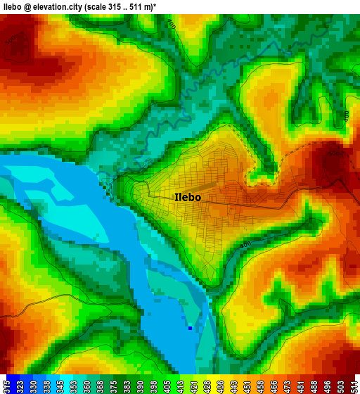
Below is the Elevation map of Ilebo, which displays elevation range with different colors. Scale of the first map is from 315 to 511 m (1033 to 1677 ft) with average elevation of 412.2 meters (=1352 ft) [note 1]
These maps also provides idea of topography and contour of this city, they are displayed at different zoom levels. More info about maps, scale and edge coordinates you can find below images.
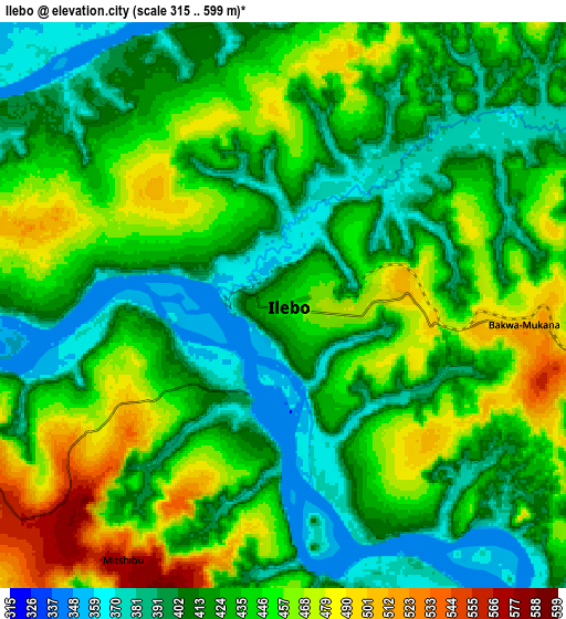
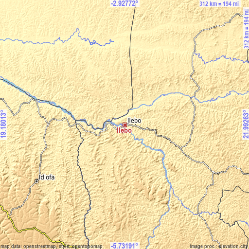
| \ | Map #1 | Map #2 | Topo.Map |
| Scale [m] | 315..511 m | 315..599 m | × |
| Scale [ft] | 1033..1677 ft | 1033..1965 ft | × |
| Average | 412.2 m = 1352 ft | 430.1 m = 1411 ft | × |
| Width | 9.74 km = 6.1 mi | 19.49 km = 12.1 mi | 311.8 km = 193.7 mi |
| Height | 9.74 km = 6.1 mi | 19.49 km = 12.1 mi | 311.8 km = 193.7 mi |
| ↑Max Latitude | -4.287289° | -4.243465° | -2.92772° |
| Latitude at center | -4.33111° | -4.33111° | -4.33111° |
| ↓Min Latitude | -4.374929° | -4.418745° | -5.73191° |
| ← Min Longitude | 20.542435° | 20.498489° | 19.18013° |
| Longitude center | 20.58638° | 20.58638° | 20.58638° |
| →Max Longitude | 20.630325° | 20.674271° | 21.99263° |
Nearby cities:
Cities around Ilebo sort by population:
• Kananga elevation 643 m
267.1 km,  130°
130°
• Tshikapa 484 m
233 km,  174°
174°
• Kikwit 466 m
211.5 km,  248°
248°
• Lodja 478 m
346.3 km,  74°
74°
• Mweka 591 m
122.4 km,  118°
118°
• Bulungu 400 m
221.1 km,  263°
263°
• Lusambo 432 m
324.7 km,  102°
102°
• Nioki 326 m
368 km,  299°
299°
• Inongo 318 m
369.5 km,  316°
316°
• Mangai 342 m
121.6 km,  286°
286°
• Luebo 498 m
146.5 km,  140°
140°
• Demba 632 m
227 km, 124°
Multilingual:
 En español:
Ilebo elevación 440 m.
 En France:
Ilebo élévation 440 m.


Sources and notes:
- [note 1] Map square and city borders are not equal. Map elevation data is calculated only from area inside that square.
- [src 1] Elevation data from geonames database provided with same terms of usage.
- [src 2] The elevation map of Ilebo is generated using elevation data from NASA's 3 arcsec (90m) resolution SRTM data.
- [src 3] Base (background) map © OpenStreetMap contributors tiles are generated by Geofabrik and OpenTopoMap.
Copyright & License:
This Ilebo Elevation Map is licensed under CC BY-SA. You may reuse any part from this page, if you give a proper credit by linking to this URL:
 More info on terms of use page.