Vanderhoof elevation
Vanderhoof (British Columbia, Regional District of Bulkley-Nechako), Canada elevation is 635 meters and Vanderhoof elevation in feet is 2083 ft above sea level [src 1]. Vanderhoof is a populated place (feature code) with elevation that is 377 meters (1237 ft) bigger than average city elevation in Canada.
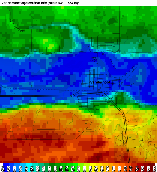
Below is the Elevation map of Vanderhoof, which displays elevation range with different colors. Scale of the first map is from 631 to 733 m (2070 to 2405 ft) with average elevation of 672.5 meters (=2206 ft) [note 1]
These maps also provides idea of topography and contour of this city, they are displayed at different zoom levels. More info about maps, scale and edge coordinates you can find below images.
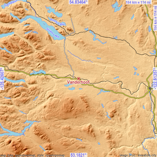
| \ | Map #1 | Topo.Map |
| Scale [m] | 631..733 m | × |
| Scale [ft] | 2070..2405 ft | × |
| Average | 672.5 m = 2206 ft | × |
| Width | 5.74 km = 3.6 mi | 183.7 km = 114.1 mi |
| Height | 5.74 km = 3.6 mi | 183.7 km = 114.1 mi |
| ↑Max Latitude | 54.042382° | 54.83464° |
| Latitude at center | 54.01657° | 54.01657° |
| ↓Min Latitude | 53.990742° | 53.1821° |
| ← Min Longitude | -124.063765° | -125.42607° |
| Longitude center | -124.01982° | -124.01982° |
| →Max Longitude | -123.975875° | -122.61357° |
Nearby cities:
Cities around Vanderhoof sort by population:
• Prince George elevation 578 m
83.6 km,  97°
97°
• Fort St. John 696 m
319.6 km,  39°
39°
• Williams Lake 674 m
243.2 km,  149°
149°
• Quesnel 479 m
153.4 km,  138°
138°
• Hanceville 691 m
242.2 km,  164°
164°
• Smithers 494 m
221.1 km,  292°
292°
• Mackenzie 771 m
158.4 km,  22°
22°
• Houston 590 m
177.5 km,  283°
283°
• Burns Lake 724 m
115.9 km, 281°
• Chetwynd 653 m
241.4 km, 39°
• Tumbler Ridge 838 m
231 km,  57°
57°
• Clinton 974 m
365.3 km, 153°
Multilingual:
 En español:
Vanderhoof elevación 635 m.
 En France:
Vanderhoof élévation 635 m.
 Auf Deutsch:
Vanderhoof höhe über dem Meeresspiegel ist 635 m.

Sources and notes:
- [note 1] Map square and city borders are not equal. Map elevation data is calculated only from area inside that square.
- [src 1] Elevation data from geonames database provided with same terms of usage.
- [src 2] The elevation map of Vanderhoof is generated using elevation data from NASA's 3 arcsec (90m) resolution SRTM data.
- [src 3] Base (background) map © OpenStreetMap contributors tiles are generated by Geofabrik and OpenTopoMap.
Copyright & License:
This Vanderhoof Elevation Map is licensed under CC BY-SA. You may reuse any part from this page, if you give a proper credit by linking to this URL:
 More info on terms of use page.