Fort St. John elevation
Fort St. John (British Columbia, Peace River Regional District), Canada elevation is 696 meters and Fort St. John elevation in feet is 2283 ft above sea level [src 1]. Fort St. John is a populated place (feature code) with elevation that is 438 meters (1437 ft) bigger than average city elevation in Canada.
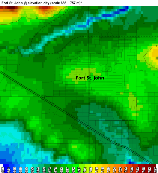
Below is the Elevation map of Fort St. John, which displays elevation range with different colors. Scale of the first map is from 636 to 757 m (2087 to 2484 ft) with average elevation of 680.8 meters (=2234 ft) [note 1]
These maps also provides idea of topography and contour of this city, they are displayed at different zoom levels. More info about maps, scale and edge coordinates you can find below images.
| \ | Map #1 | Map #2 | Topo.Map |
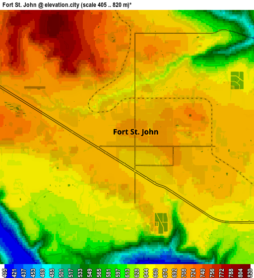
| Scale [m] | 636..757 m | 405..820 m | × |
| Scale [ft] | 2087..2484 ft | 1329..2690 ft | × |
| Average | 680.8 m = 2234 ft | 662.3 m = 2173 ft | × |
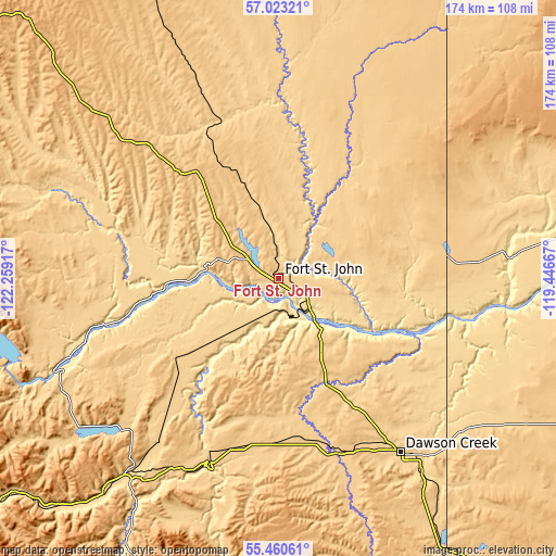
| Width | 5.43 km = 3.4 mi | 10.86 km = 6.7 mi | 173.7 km = 107.9 mi |
| Height | 5.43 km = 3.4 mi | 10.86 km = 6.7 mi | 173.7 km = 107.9 mi |
| ↑Max Latitude | 56.274287° | 56.298678° | 57.02321° |
| Latitude at center | 56.24988° | 56.24988° | 56.24988° |
| ↓Min Latitude | 56.225457° | 56.201019° | 55.46061° |
| ← Min Longitude | -120.896865° | -120.940811° | -122.25917° |
| Longitude center | -120.85292° | -120.85292° | -120.85292° |
| →Max Longitude | -120.808975° | -120.765029° | -119.44667° |
Nearby cities:
Cities around Fort St. John sort by population:
• Grande Prairie elevation 653 m
176.1 km,  133°
133°
• Dawson Creek 663 m
66.5 km,  145°
145°
• Fairview 655 m
154.1 km,  97°
97°
• Mackenzie 771 m
173 km,  234°
234°
• Chetwynd 653 m
78.2 km,  218°
218°
• Grimshaw 598 m
201.1 km,  92°
92°
• Sexsmith 719 m
163.4 km, 127°
• Tumbler Ridge 838 m
124.8 km,  184°
184°
• Beaverlodge 723 m
145.1 km,  142°
142°
• Wembley 729 m
162.9 km, 138°
• Westlake 677 m
171.8 km, 131°
• Spirit River 616 m
135.7 km,  112°
112°
Multilingual:
 En español:
Fort St. John elevación 696 m.
 En France:
Fort St. John élévation 696 m.
 Auf Deutsch:
Fort St. John höhe über dem Meeresspiegel ist 696 m.

Sources and notes:
- [note 1] Map square and city borders are not equal. Map elevation data is calculated only from area inside that square.
- [src 1] Elevation data from geonames database provided with same terms of usage.
- [src 2] The elevation map of Fort St. John is generated using elevation data from NASA's 3 arcsec (90m) resolution SRTM data.
- [src 3] Base (background) map © OpenStreetMap contributors tiles are generated by Geofabrik and OpenTopoMap.
Copyright & License:
This Fort St. John Elevation Map is licensed under CC BY-SA. You may reuse any part from this page, if you give a proper credit by linking to this URL:
 More info on terms of use page.