Grande Prairie elevation
Grande Prairie (Alberta), Canada elevation is 653 meters and Grande Prairie elevation in feet is 2142 ft above sea level [src 1]. Grande Prairie is a populated place (feature code) with elevation that is 395 meters (1296 ft) bigger than average city elevation in Canada.
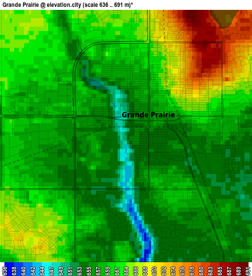
Below is the Elevation map of Grande Prairie, which displays elevation range with different colors. Scale of the first map is from 636 to 691 m (2087 to 2267 ft) with average elevation of 660.2 meters (=2166 ft) [note 1]
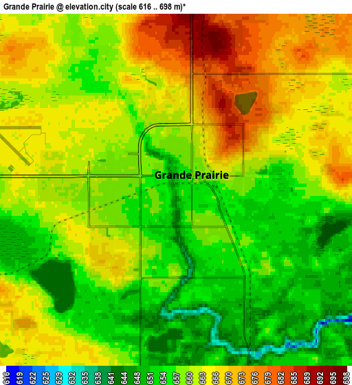
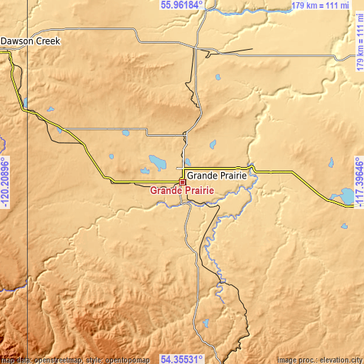
These maps also provides idea of topography and contour of this city, they are displayed at different zoom levels. More info about maps, scale and edge coordinates you can find below images.
| \ | Map #1 | Map #2 | Topo.Map |
| Scale [m] | 636..691 m | 616..698 m | × |
| Scale [ft] | 2087..2267 ft | 2021..2290 ft | × |
| Average | 660.2 m = 2166 ft | 660.8 m = 2168 ft | × |
| Width | 5.58 km = 3.5 mi | 11.16 km = 6.9 mi | 178.6 km = 111 mi |
| Height | 5.58 km = 3.5 mi | 11.16 km = 6.9 mi | 178.6 km = 111 mi |
| ↑Max Latitude | 55.191763° | 55.216841° | 55.96184° |
| Latitude at center | 55.16667° | 55.16667° | 55.16667° |
| ↓Min Latitude | 55.141561° | 55.116436° | 54.35531° |
| ← Min Longitude | -118.846655° | -118.890601° | -120.20896° |
| Longitude center | -118.80271° | -118.80271° | -118.80271° |
| →Max Longitude | -118.758765° | -118.714819° | -117.39646° |
Nearby cities:
Cities around Grande Prairie sort by population:
• Dawson Creek elevation 663 m
112.1 km,  306°
306°
• Grande Cache 1225 m
144.3 km,  188°
188°
• Fairview 655 m
103.4 km,  14°
14°
• Grimshaw 598 m
135.8 km,  33°
33°
• Sexsmith 719 m
20.4 km,  2°
2°
• Tumbler Ridge 838 m
139.3 km,  268°
268°
• Beaverlodge 723 m
40.6 km,  277°
277°
• Valleyview 692 m
97.1 km,  96°
96°
• Wembley 729 m
21.3 km,  264°
264°
• Westlake 677 m
6.2 km,  359°
359°
• Falher 578 m
119 km,  58°
58°
• Spirit River 616 m
68.6 km, 358°
Multilingual:
 En español:
Grande Prairie elevación 653 m.
 En France:
Grande Prairie élévation 653 m.
 Auf Deutsch:
Grande Prairie höhe über dem Meeresspiegel ist 653 m.

Sources and notes:
- [note 1] Map square and city borders are not equal. Map elevation data is calculated only from area inside that square.
- [src 1] Elevation data from geonames database provided with same terms of usage.
- [src 2] The elevation map of Grande Prairie is generated using elevation data from NASA's 3 arcsec (90m) resolution SRTM data.
- [src 3] Base (background) map © OpenStreetMap contributors tiles are generated by Geofabrik and OpenTopoMap.
Copyright & License:
This Grande Prairie Elevation Map is licensed under CC BY-SA. You may reuse any part from this page, if you give a proper credit by linking to this URL:
 More info on terms of use page.