Hanceville elevation
Hanceville (British Columbia), Canada elevation is 691 meters and Hanceville elevation in feet is 2267 ft above sea level [src 1]. Hanceville is a populated locality (feature code) with elevation that is 433 meters (1421 ft) bigger than average city elevation in Canada.
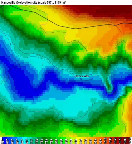
Below is the Elevation map of Hanceville, which displays elevation range with different colors. Scale of the first map is from 597 to 1119 m (1959 to 3671 ft) with average elevation of 788.3 meters (=2586 ft) [note 1]
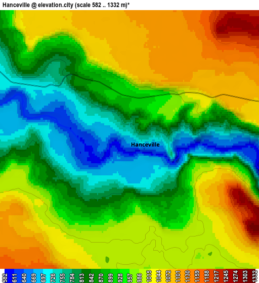
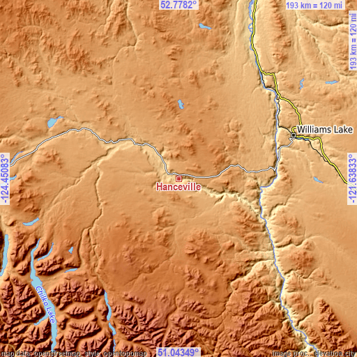
These maps also provides idea of topography and contour of this city, they are displayed at different zoom levels. More info about maps, scale and edge coordinates you can find below images.
| \ | Map #1 | Map #2 | Topo.Map |
| Scale [m] | 597..1119 m | 582..1332 m | × |
| Scale [ft] | 1959..3671 ft | 1909..4370 ft | × |
| Average | 788.3 m = 2586 ft | 933.2 m = 3062 ft | × |
| Width | 6.03 km = 3.7 mi | 12.05 km = 7.5 mi | 192.9 km = 119.9 mi |
| Height | 6.03 km = 3.7 mi | 12.05 km = 7.5 mi | 192.9 km = 119.9 mi |
| ↑Max Latitude | 51.946316° | 51.973396° | 52.7782° |
| Latitude at center | 51.91922° | 51.91922° | 51.91922° |
| ↓Min Latitude | 51.892108° | 51.864979° | 51.04349° |
| ← Min Longitude | -123.088525° | -123.132471° | -124.45083° |
| Longitude center | -123.04458° | -123.04458° | -123.04458° |
| →Max Longitude | -123.000635° | -122.956689° | -121.63833° |
Nearby cities:
Cities around Hanceville sort by population:
• Kamloops elevation 414 m
235.2 km,  126°
126°
• Prince George 578 m
222.9 km,  5°
5°
• Williams Lake 674 m
66.3 km,  68°
68°
• Quesnel 479 m
123.6 km,  17°
17°
• Whistler 714 m
200.4 km,  178°
178°
• Lillooet 276 m
157.1 km,  150°
150°
• Pemberton 211 m
179 km,  174°
174°
• Logan Lake 1136 m
222 km,  135°
135°
• Ashcroft 307 m
180.7 km, 137°
• Barrière 399 m
218.2 km,  112°
112°
• Cache Creek 464 m
171.6 km, 135°
• Clinton 974 m
137.2 km, 132°
Multilingual:
 En español:
Hanceville elevación 691 m.
 En France:
Hanceville élévation 691 m.
 Auf Deutsch:
Hanceville höhe über dem Meeresspiegel ist 691 m.

Sources and notes:
- [note 1] Map square and city borders are not equal. Map elevation data is calculated only from area inside that square.
- [src 1] Elevation data from geonames database provided with same terms of usage.
- [src 2] The elevation map of Hanceville is generated using elevation data from NASA's 3 arcsec (90m) resolution SRTM data.
- [src 3] Base (background) map © OpenStreetMap contributors tiles are generated by Geofabrik and OpenTopoMap.
Copyright & License:
This Hanceville Elevation Map is licensed under CC BY-SA. You may reuse any part from this page, if you give a proper credit by linking to this URL:
 More info on terms of use page.