Rayside-Balfour elevation
Rayside-Balfour (Ontario), Canada elevation is 280 meters and Rayside-Balfour elevation in feet is 919 ft above sea level [src 1]. Rayside-Balfour is a populated place (feature code) with elevation that is 22 meters (72 ft) bigger than average city elevation in Canada.
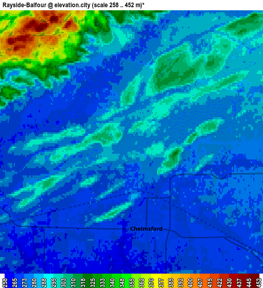
Below is the Elevation map of Rayside-Balfour, which displays elevation range with different colors. Scale of the first map is from 263 to 319 m (863 to 1047 ft) with average elevation of 279.6 meters (=917 ft) [note 1]
These maps also provides idea of topography and contour of this city, they are displayed at different zoom levels. More info about maps, scale and edge coordinates you can find below images.

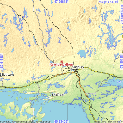
| \ | Map #1 | Map #2 | Topo.Map |
| Scale [m] | 263..319 m | 258..452 m | × |
| Scale [ft] | 863..1047 ft | 846..1483 ft | × |
| Average | 279.6 m = 917 ft | 285.4 m = 936 ft | × |
| Width | 6.71 km = 4.2 mi | 13.43 km = 8.3 mi | 214.8 km = 133.5 mi |
| Height | 6.71 km = 4.2 mi | 13.43 km = 8.3 mi | 214.8 km = 133.5 mi |
| ↑Max Latitude | 46.638911° | 46.669075° | 47.56618° |
| Latitude at center | 46.60873° | 46.60873° | 46.60873° |
| ↓Min Latitude | 46.578532° | 46.548318° | 45.63405° |
| ← Min Longitude | -81.251575° | -81.295521° | -82.61388° |
| Longitude center | -81.20763° | -81.20763° | -81.20763° |
| →Max Longitude | -81.163685° | -81.119739° | -79.80138° |
Nearby cities:
Cities around Rayside-Balfour sort by population:
• Greater Sudbury elevation 266 m
21.2 km,  128°
128°
• North Bay 206 m
137.3 km,  103°
103°
• Valley East 304 m
17.1 km,  67°
67°
• Elliot Lake 310 m
112 km,  257°
257°
• Temiskaming Shores 248 m
149.9 km,  48°
48°
• Lively 270 m
20 km,  167°
167°
• Espanola 204 m
57.9 km,  227°
227°
• Azilda 270 m
10.5 km, 128°
• Capreol 308 m
24.4 km,  63°
63°
• Little Current 190 m
89.1 km,  218°
218°
• Dowling 270 m
10.2 km, 258°
• Tobermory 192 m
155.2 km,  193°
193°
Multilingual:
 En español:
Rayside-Balfour elevación 280 m.
 En France:
Rayside-Balfour élévation 280 m.
 Auf Deutsch:
Rayside-Balfour höhe über dem Meeresspiegel ist 280 m.

Sources and notes:
- [note 1] Map square and city borders are not equal. Map elevation data is calculated only from area inside that square.
- [src 1] Elevation data from geonames database provided with same terms of usage.
- [src 2] The elevation map of Rayside-Balfour is generated using elevation data from NASA's 3 arcsec (90m) resolution SRTM data.
- [src 3] Base (background) map © OpenStreetMap contributors tiles are generated by Geofabrik and OpenTopoMap.
Copyright & License:
This Rayside-Balfour Elevation Map is licensed under CC BY-SA. You may reuse any part from this page, if you give a proper credit by linking to this URL:
 More info on terms of use page.