Temiskaming Shores elevation
Temiskaming Shores (Ontario), Canada elevation is 248 meters and Temiskaming Shores elevation in feet is 814 ft above sea level [src 1]. Temiskaming Shores is a populated place (feature code) with elevation that is 10 meters (33 ft) smaller than average city elevation in Canada.
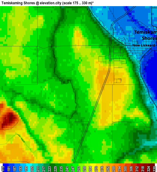
Below is the Elevation map of Temiskaming Shores, which displays elevation range with different colors. Scale of the first map is from 175 to 330 m (574 to 1083 ft) with average elevation of 243.1 meters (=798 ft) [note 1]
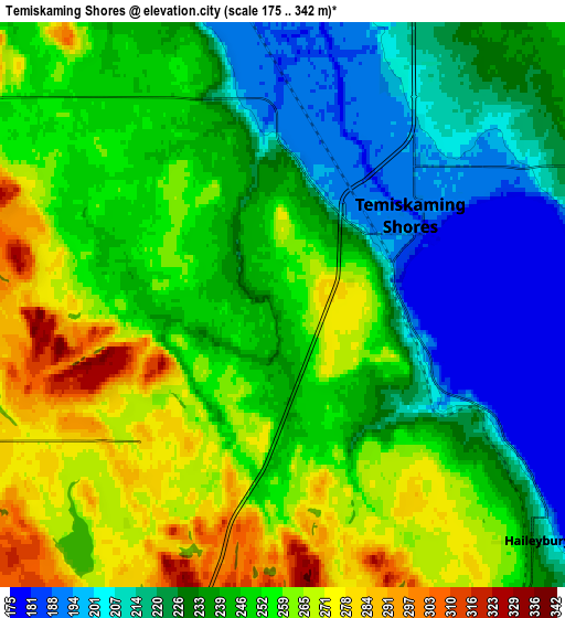
These maps also provides idea of topography and contour of this city, they are displayed at different zoom levels. More info about maps, scale and edge coordinates you can find below images.
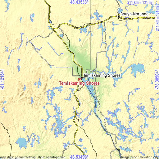
| \ | Map #1 | Map #2 | Topo.Map |
| Scale [m] | 175..330 m | 175..342 m | × |
| Scale [ft] | 574..1083 ft | 574..1122 ft | × |
| Average | 243.1 m = 798 ft | 242 m = 794 ft | × |
| Width | 6.6 km = 4.1 mi | 13.21 km = 8.2 mi | 211.3 km = 131.3 mi |
| Height | 6.6 km = 4.1 mi | 13.21 km = 8.2 mi | 211.3 km = 131.3 mi |
| ↑Max Latitude | 47.523444° | 47.553112° | 48.43533° |
| Latitude at center | 47.49376° | 47.49376° | 47.49376° |
| ↓Min Latitude | 47.464059° | 47.434341° | 46.53499° |
| ← Min Longitude | -79.759235° | -79.803181° | -81.12154° |
| Longitude center | -79.71529° | -79.71529° | -79.71529° |
| →Max Longitude | -79.671345° | -79.627399° | -78.30904° |
Nearby cities:
Cities around Temiskaming Shores sort by population:
• North Bay elevation 206 m
132.2 km,  171°
171°
• Rouyn-Noranda 299 m
97.4 km,  32°
32°
• Valley East 304 m
133.8 km,  226°
226°
• Kirkland Lake 321 m
76.3 km,  341°
341°
• Malartic 324 m
137.9 km,  58°
58°
• Saint-Bruno-de-Guigues 228 m
21.4 km,  98°
98°
• Ville-Marie 204 m
27.7 km,  130°
130°
• Capreol 308 m
126.5 km, 226°
• Témiscaming 240 m
97.8 km,  151°
151°
• Englehart 201 m
37.7 km, 342°
• Notre-Dame-du-Lac 248 m
96.8 km, 148°
• Saint-Isidore 274 m
32 km, 102°
Multilingual:
 En español:
Temiskaming Shores elevación 248 m.
 En France:
Temiskaming Shores élévation 248 m.
 Auf Deutsch:
New Liskeard höhe über dem Meeresspiegel ist 248 m.
 На русском:
Temiskaming Shores высота над уровнем моря 248 м
Sources and notes:
- [note 1] Map square and city borders are not equal. Map elevation data is calculated only from area inside that square.
- [src 1] Elevation data from geonames database provided with same terms of usage.
- [src 2] The elevation map of Temiskaming Shores is generated using elevation data from NASA's 3 arcsec (90m) resolution SRTM data.
- [src 3] Base (background) map © OpenStreetMap contributors tiles are generated by Geofabrik and OpenTopoMap.
Copyright & License:
This Temiskaming Shores Elevation Map is licensed under CC BY-SA. You may reuse any part from this page, if you give a proper credit by linking to this URL:
 More info on terms of use page.