Kirkland Lake elevation
Kirkland Lake (Ontario), Canada elevation is 321 meters and Kirkland Lake elevation in feet is 1053 ft above sea level [src 1]. Kirkland Lake is a populated place (feature code) with elevation that is 63 meters (207 ft) bigger than average city elevation in Canada.
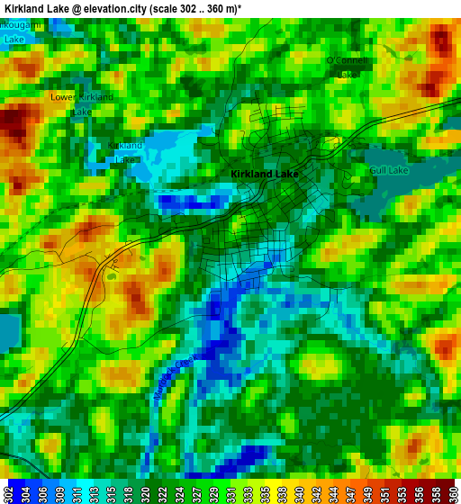
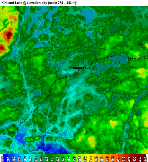
Below is the Elevation map of Kirkland Lake, which displays elevation range with different colors. Scale of the first map is from 302 to 360 m (991 to 1181 ft) with average elevation of 325.9 meters (=1069 ft) [note 1]
These maps also provides idea of topography and contour of this city, they are displayed at different zoom levels. More info about maps, scale and edge coordinates you can find below images.
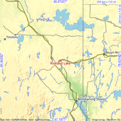
| \ | Map #1 | Map #2 | Topo.Map |
| Scale [m] | 302..360 m | 274..443 m | × |
| Scale [ft] | 991..1181 ft | 899..1453 ft | × |
| Average | 325.9 m = 1069 ft | 329.2 m = 1080 ft | × |
| Width | 6.52 km = 4.1 mi | 13.04 km = 8.1 mi | 208.7 km = 129.7 mi |
| Height | 6.52 km = 4.1 mi | 13.04 km = 8.1 mi | 208.7 km = 129.7 mi |
| ↑Max Latitude | 48.173924° | 48.203222° | 49.07437° |
| Latitude at center | 48.14461° | 48.14461° | 48.14461° |
| ↓Min Latitude | 48.115279° | 48.085931° | 47.1977° |
| ← Min Longitude | -80.081615° | -80.125561° | -81.44392° |
| Longitude center | -80.03767° | -80.03767° | -80.03767° |
| →Max Longitude | -79.993725° | -79.949779° | -78.63142° |
Nearby cities:
Cities around Kirkland Lake sort by population:
• Timmins elevation 301 m
102.3 km,  290°
290°
• Rouyn-Noranda 299 m
75.9 km,  82°
82°
• Amos 298 m
149.5 km,  71°
71°
• Temiskaming Shores 248 m
76.3 km,  161°
161°
• La Sarre 269 m
95.5 km,  40°
40°
• Iroquois Falls 280 m
84 km,  325°
325°
• Malartic 324 m
141.3 km,  90°
90°
• Saint-Bruno-de-Guigues 228 m
87.9 km,  149°
149°
• Ville-Marie 204 m
100.9 km, 153°
• Englehart 201 m
38.6 km, 160°
• Macamic 283 m
102 km,  48°
48°
• Saint-Isidore 274 m
96.4 km, 145°
Multilingual:
 En español:
Kirkland Lake elevación 321 m.
 En France:
Kirkland Lake élévation 321 m.
 Auf Deutsch:
Kirkland Lake höhe über dem Meeresspiegel ist 321 m.

Sources and notes:
- [note 1] Map square and city borders are not equal. Map elevation data is calculated only from area inside that square.
- [src 1] Elevation data from geonames database provided with same terms of usage.
- [src 2] The elevation map of Kirkland Lake is generated using elevation data from NASA's 3 arcsec (90m) resolution SRTM data.
- [src 3] Base (background) map © OpenStreetMap contributors tiles are generated by Geofabrik and OpenTopoMap.
Copyright & License:
This Kirkland Lake Elevation Map is licensed under CC BY-SA. You may reuse any part from this page, if you give a proper credit by linking to this URL:
 More info on terms of use page.