North Bay elevation
North Bay (Ontario, Nipissing District), Canada elevation is 206 meters and North Bay elevation in feet is 676 ft above sea level [src 1]. North Bay is a populated place (feature code) with elevation that is 52 meters (171 ft) smaller than average city elevation in Canada.
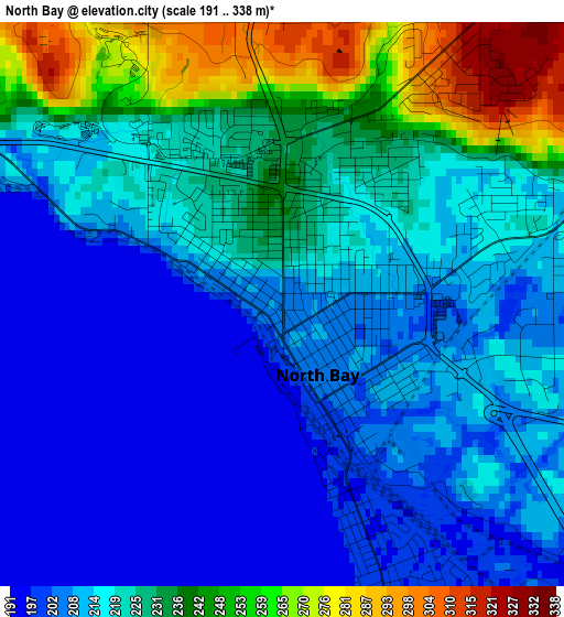
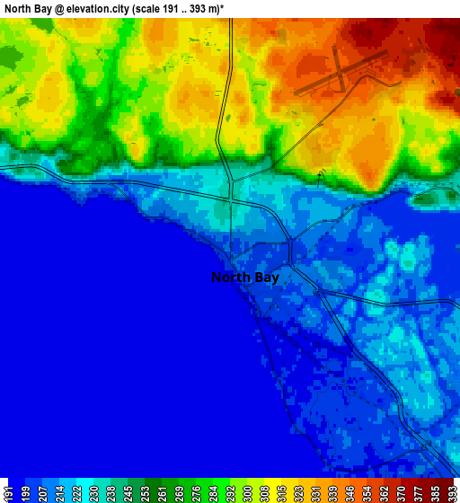
Below is the Elevation map of North Bay, which displays elevation range with different colors. Scale of the first map is from 191 to 338 m (627 to 1109 ft) with average elevation of 219.8 meters (=721 ft) [note 1]
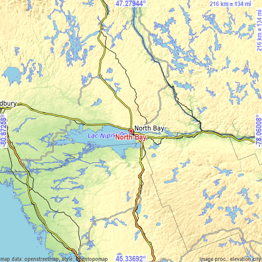
These maps also provides idea of topography and contour of this city, they are displayed at different zoom levels. More info about maps, scale and edge coordinates you can find below images.
| \ | Map #1 | Map #2 | Topo.Map |
| Scale [m] | 191..338 m | 191..393 m | × |
| Scale [ft] | 627..1109 ft | 627..1289 ft | × |
| Average | 219.8 m = 721 ft | 239.5 m = 786 ft | × |
| Width | 6.75 km = 4.2 mi | 13.5 km = 8.4 mi | 216 km = 134.2 mi |
| Height | 6.75 km = 4.2 mi | 13.5 km = 8.4 mi | 216 km = 134.2 mi |
| ↑Max Latitude | 46.347143° | 46.37747° | 47.27944° |
| Latitude at center | 46.3168° | 46.3168° | 46.3168° |
| ↓Min Latitude | 46.28644° | 46.256063° | 45.33692° |
| ← Min Longitude | -79.510275° | -79.554221° | -80.87258° |
| Longitude center | -79.46633° | -79.46633° | -79.46633° |
| →Max Longitude | -79.422385° | -79.378439° | -78.06008° |
Nearby cities:
Cities around North Bay sort by population:
• Greater Sudbury elevation 266 m
118.4 km,  279°
279°
• Huntsville 302 m
111 km,  169°
169°
• Valley East 304 m
123.7 km,  288°
288°
• Parry Sound 199 m
116.5 km,  202°
202°
• Ville-Marie 204 m
113.1 km,  1°
1°
• Capreol 308 m
119.4 km, 291°
• Mattawa 161 m
58.9 km,  89°
89°
• Témiscaming 240 m
53.1 km,  32°
32°
• Powassan 330 m
32.8 km,  164°
164°
• South River 369 m
54.1 km, 173°
• Notre-Dame-du-Lac 248 m
57.8 km, 33°
• Saint-Isidore 274 m
124.8 km,  5°
5°
Multilingual:
 En español:
North Bay elevación 206 m.
 En France:
North Bay élévation 206 m.
 Auf Deutsch:
North Bay höhe über dem Meeresspiegel ist 206 m.

Sources and notes:
- [note 1] Map square and city borders are not equal. Map elevation data is calculated only from area inside that square.
- [src 1] Elevation data from geonames database provided with same terms of usage.
- [src 2] The elevation map of North Bay is generated using elevation data from NASA's 3 arcsec (90m) resolution SRTM data.
- [src 3] Base (background) map © OpenStreetMap contributors tiles are generated by Geofabrik and OpenTopoMap.
Copyright & License:
This North Bay Elevation Map is licensed under CC BY-SA. You may reuse any part from this page, if you give a proper credit by linking to this URL:
 More info on terms of use page.