Mattawa elevation
Mattawa (Ontario), Canada elevation is 161 meters and Mattawa elevation in feet is 528 ft above sea level [src 1]. Mattawa is a populated place (feature code) with elevation that is 97 meters (318 ft) smaller than average city elevation in Canada.
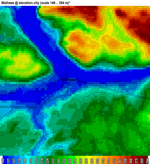
Below is the Elevation map of Mattawa, which displays elevation range with different colors. Scale of the first map is from 148 to 394 m (486 to 1293 ft) with average elevation of 228.1 meters (=748 ft) [note 1]
These maps also provides idea of topography and contour of this city, they are displayed at different zoom levels. More info about maps, scale and edge coordinates you can find below images.
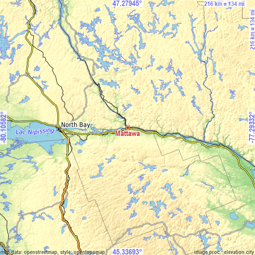
| \ | Map #1 | Topo.Map |
| Scale [m] | 148..394 m | × |
| Scale [ft] | 486..1293 ft | × |
| Average | 228.1 m = 748 ft | × |
| Width | 6.75 km = 4.2 mi | 216 km = 134.2 mi |
| Height | 6.75 km = 4.2 mi | 216 km = 134.2 mi |
| ↑Max Latitude | 46.347153° | 47.27945° |
| Latitude at center | 46.31681° | 46.31681° |
| ↓Min Latitude | 46.28645° | 45.33693° |
| ← Min Longitude | -78.743515° | -80.10582° |
| Longitude center | -78.69957° | -78.69957° |
| →Max Longitude | -78.655625° | -77.29332° |
Nearby cities:
Cities around Mattawa sort by population:
• North Bay elevation 206 m
58.9 km,  269°
269°
• Huntsville 302 m
116.4 km,  200°
200°
• Petawawa 143 m
119.1 km,  113°
113°
• Pembroke 120 m
134.2 km, 114°
• Deep River 146 m
95.4 km,  104°
104°
• Saint-Bruno-de-Guigues 228 m
139.5 km,  336°
336°
• Ville-Marie 204 m
126.1 km,  333°
333°
• Témiscaming 240 m
54.3 km, 325°
• Powassan 330 m
59.1 km,  237°
237°
• South River 369 m
75.3 km,  224°
224°
• Notre-Dame-du-Lac 248 m
55.1 km, 330°
• Saint-Isidore 274 m
132.3 km, 339°
Multilingual:
 En español:
Mattawa elevación 161 m.
 En France:
Mattawa élévation 161 m.


Sources and notes:
- [note 1] Map square and city borders are not equal. Map elevation data is calculated only from area inside that square.
- [src 1] Elevation data from geonames database provided with same terms of usage.
- [src 2] The elevation map of Mattawa is generated using elevation data from NASA's 3 arcsec (90m) resolution SRTM data.
- [src 3] Base (background) map © OpenStreetMap contributors tiles are generated by Geofabrik and OpenTopoMap.
Copyright & License:
This Mattawa Elevation Map is licensed under CC BY-SA. You may reuse any part from this page, if you give a proper credit by linking to this URL:
 More info on terms of use page.