Tobermory elevation
Tobermory (Ontario, Bruce County), Canada elevation is 192 meters and Tobermory elevation in feet is 630 ft above sea level [src 1]. Tobermory is a populated place (feature code) with elevation that is 66 meters (217 ft) smaller than average city elevation in Canada.
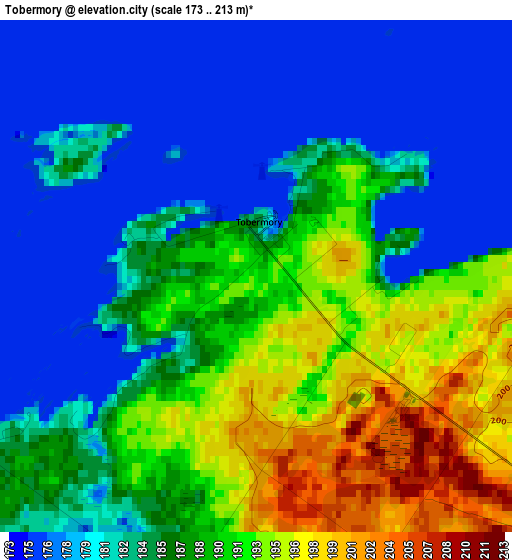
Below is the Elevation map of Tobermory, which displays elevation range with different colors. Scale of the first map is from 173 to 213 m (568 to 699 ft) with average elevation of 185.4 meters (=608 ft) [note 1]
These maps also provides idea of topography and contour of this city, they are displayed at different zoom levels. More info about maps, scale and edge coordinates you can find below images.
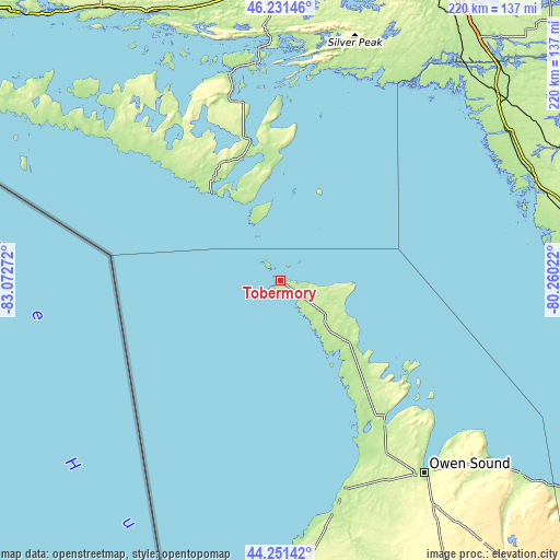
| \ | Map #1 | Topo.Map |
| Scale [m] | 173..213 m | × |
| Scale [ft] | 568..699 ft | × |
| Average | 185.4 m = 608 ft | × |
| Width | 6.88 km = 4.3 mi | 220.2 km = 136.8 mi |
| Height | 6.88 km = 4.3 mi | 220.1 km = 136.8 mi |
| ↑Max Latitude | 45.281° | 46.23146° |
| Latitude at center | 45.25007° | 45.25007° |
| ↓Min Latitude | 45.219123° | 44.25142° |
| ← Min Longitude | -81.710415° | -83.07272° |
| Longitude center | -81.66647° | -81.66647° |
| →Max Longitude | -81.622525° | -80.26022° |
Nearby cities:
Cities around Tobermory sort by population:
• Owen Sound elevation 180 m
94.9 km,  143°
143°
• Collingwood 194 m
142.6 km,  126°
126°
• Hanover 277 m
132.2 km,  157°
157°
• Kincardine 195 m
118.6 km,  178°
178°
• Parry Sound 199 m
128 km,  85°
85°
• Lively 270 m
137.5 km,  16°
16°
• Meaford 202 m
109.6 km, 130°
• Espanola 204 m
112.4 km,  356°
356°
• Little Current 190 m
83.5 km,  346°
346°
• Mildmay 312 m
140.3 km, 161°
• Markdale 424 m
131.2 km, 142°
• Paisley 214 m
109.4 km, 163°
Multilingual:
 En español:
Tobermory elevación 192 m.
 En France:
Tobermory élévation 192 m.
 Auf Deutsch:
Tobermory höhe über dem Meeresspiegel ist 192 m.

Sources and notes:
- [note 1] Map square and city borders are not equal. Map elevation data is calculated only from area inside that square.
- [src 1] Elevation data from geonames database provided with same terms of usage.
- [src 2] The elevation map of Tobermory is generated using elevation data from NASA's 3 arcsec (90m) resolution SRTM data.
- [src 3] Base (background) map © OpenStreetMap contributors tiles are generated by Geofabrik and OpenTopoMap.
Copyright & License:
This Tobermory Elevation Map is licensed under CC BY-SA. You may reuse any part from this page, if you give a proper credit by linking to this URL:
 More info on terms of use page.