Orillia elevation
Orillia (Ontario), Canada elevation is 232 meters and Orillia elevation in feet is 761 ft above sea level [src 1]. Orillia is a populated place (feature code) with elevation that is 26 meters (85 ft) smaller than average city elevation in Canada.
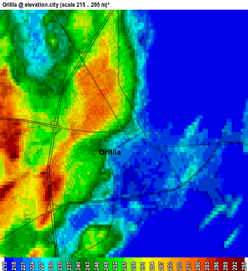
Below is the Elevation map of Orillia, which displays elevation range with different colors. Scale of the first map is from 215 to 295 m (705 to 968 ft) with average elevation of 236.1 meters (=775 ft) [note 1]
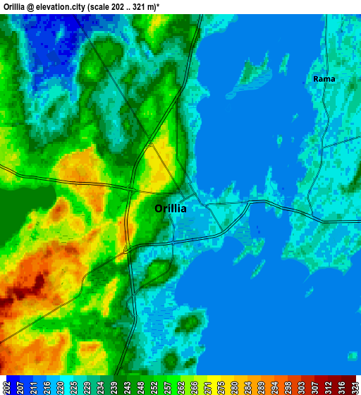
These maps also provides idea of topography and contour of this city, they are displayed at different zoom levels. More info about maps, scale and edge coordinates you can find below images.
| \ | Map #1 | Map #2 | Topo.Map |
| Scale [m] | 215..295 m | 202..321 m | × |
| Scale [ft] | 705..968 ft | 663..1053 ft | × |
| Average | 236.1 m = 775 ft | 235.1 m = 771 ft | × |
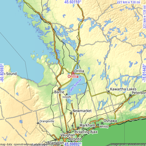
| Width | 6.96 km = 4.3 mi | 13.91 km = 8.6 mi | 222.6 km = 138.3 mi |
| Height | 6.96 km = 4.3 mi | 13.91 km = 8.6 mi | 222.6 km = 138.3 mi |
| ↑Max Latitude | 44.639957° | 44.671217° | 45.60119° |
| Latitude at center | 44.60868° | 44.60868° | 44.60868° |
| ↓Min Latitude | 44.577386° | 44.546075° | 43.59892° |
| ← Min Longitude | -79.464625° | -79.508571° | -80.82693° |
| Longitude center | -79.42068° | -79.42068° | -79.42068° |
| →Max Longitude | -79.376735° | -79.332789° | -78.01443° |
Nearby cities:
Cities around Orillia sort by population:
• Barrie elevation 269 m
30.3 km,  220°
220°
• Midland 195 m
39.8 km,  293°
293°
• Keswick 230 m
40 km,  185°
185°
• Angus 193 m
49 km,  228°
228°
• Bracebridge 240 m
47.9 km,  9°
9°
• Wasaga Beach 188 m
48.3 km,  257°
257°
• Innisfil 266 m
38.8 km,  207°
207°
• Gravenhurst 260 m
34.5 km, 7°
• Elmvale 220 m
35.4 km,  265°
265°
• Amigo Beach 228 m
10.3 km, 9°
• Cookstown 237 m
52.2 km, 205°
• Stoney Point 216 m
39 km, 193°
Multilingual:
 En español:
Orillia elevación 232 m.
 En France:
Orillia élévation 232 m.


Sources and notes:
- [note 1] Map square and city borders are not equal. Map elevation data is calculated only from area inside that square.
- [src 1] Elevation data from geonames database provided with same terms of usage.
- [src 2] The elevation map of Orillia is generated using elevation data from NASA's 3 arcsec (90m) resolution SRTM data.
- [src 3] Base (background) map © OpenStreetMap contributors tiles are generated by Geofabrik and OpenTopoMap.
Copyright & License:
This Orillia Elevation Map is licensed under CC BY-SA. You may reuse any part from this page, if you give a proper credit by linking to this URL:
 More info on terms of use page.