Bracebridge elevation
Bracebridge (Ontario, District Municipality of Muskoka), Canada elevation is 240 meters and Bracebridge elevation in feet is 787 ft above sea level [src 1]. Bracebridge is a populated place (feature code) with elevation that is 18 meters (59 ft) smaller than average city elevation in Canada.
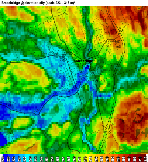
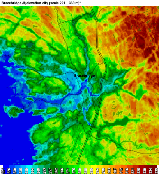
Below is the Elevation map of Bracebridge, which displays elevation range with different colors. Scale of the first map is from 223 to 313 m (732 to 1027 ft) with average elevation of 263.2 meters (=864 ft) [note 1]
These maps also provides idea of topography and contour of this city, they are displayed at different zoom levels. More info about maps, scale and edge coordinates you can find below images.
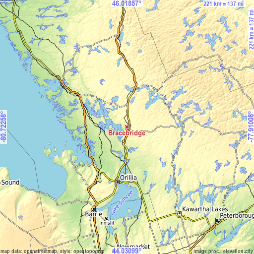
| \ | Map #1 | Map #2 | Topo.Map |
| Scale [m] | 223..313 m | 221..339 m | × |
| Scale [ft] | 732..1027 ft | 725..1112 ft | × |
| Average | 263.2 m = 864 ft | 274.6 m = 901 ft | × |
| Width | 6.91 km = 4.3 mi | 13.81 km = 8.6 mi | 221 km = 137.3 mi |
| Height | 6.91 km = 4.3 mi | 13.81 km = 8.6 mi | 221 km = 137.3 mi |
| ↑Max Latitude | 45.064457° | 45.095488° | 46.01857° |
| Latitude at center | 45.03341° | 45.03341° | 45.03341° |
| ↓Min Latitude | 45.002346° | 44.971264° | 44.03099° |
| ← Min Longitude | -79.360275° | -79.404221° | -80.72258° |
| Longitude center | -79.31633° | -79.31633° | -79.31633° |
| →Max Longitude | -79.272385° | -79.228439° | -77.91008° |
Nearby cities:
Cities around Bracebridge sort by population:
• Barrie elevation 269 m
75.7 km,  201°
201°
• Orillia 232 m
47.9 km,  189°
189°
• Midland 195 m
54.6 km,  234°
234°
• Huntsville 302 m
34.3 km,  13°
13°
• Wasaga Beach 188 m
79.7 km,  223°
223°
• Innisfil 266 m
85.7 km, 197°
• Parry Sound 199 m
66.3 km,  301°
301°
• Gravenhurst 260 m
13.5 km, 196°
• Elmvale 220 m
66.2 km, 220°
• Amigo Beach 228 m
37.6 km, 190°
• Haliburton Village 337 m
62.4 km,  88°
88°
• Stoney Point 216 m
86.9 km, 191°
Multilingual:
 En español:
Bracebridge elevación 240 m.
 En France:
Bracebridge élévation 240 m.
 Auf Deutsch:
Bracebridge höhe über dem Meeresspiegel ist 240 m.

Sources and notes:
- [note 1] Map square and city borders are not equal. Map elevation data is calculated only from area inside that square.
- [src 1] Elevation data from geonames database provided with same terms of usage.
- [src 2] The elevation map of Bracebridge is generated using elevation data from NASA's 3 arcsec (90m) resolution SRTM data.
- [src 3] Base (background) map © OpenStreetMap contributors tiles are generated by Geofabrik and OpenTopoMap.
Copyright & License:
This Bracebridge Elevation Map is licensed under CC BY-SA. You may reuse any part from this page, if you give a proper credit by linking to this URL:
 More info on terms of use page.