Angus elevation
Angus (Ontario, Simcoe County), Canada elevation is 193 meters and Angus elevation in feet is 633 ft above sea level [src 1]. Angus is a populated locality (feature code) with elevation that is 65 meters (213 ft) smaller than average city elevation in Canada.
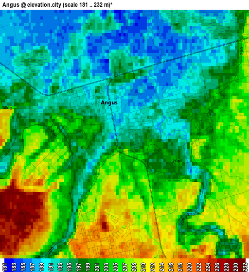
Below is the Elevation map of Angus, which displays elevation range with different colors. Scale of the first map is from 181 to 232 m (594 to 761 ft) with average elevation of 199.8 meters (=656 ft) [note 1]
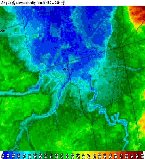
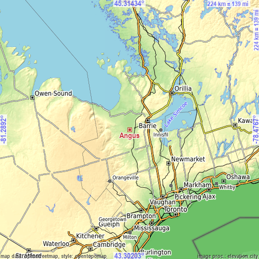
These maps also provides idea of topography and contour of this city, they are displayed at different zoom levels. More info about maps, scale and edge coordinates you can find below images.
| \ | Map #1 | Map #2 | Topo.Map |
| Scale [m] | 181..232 m | 180..289 m | × |
| Scale [ft] | 594..761 ft | 591..948 ft | × |
| Average | 199.8 m = 656 ft | 210.5 m = 691 ft | × |
| Width | 6.99 km = 4.3 mi | 13.98 km = 8.7 mi | 223.7 km = 139 mi |
| Height | 6.99 km = 4.3 mi | 13.98 km = 8.7 mi | 223.7 km = 139 mi |
| ↑Max Latitude | 44.348244° | 44.379661° | 45.31434° |
| Latitude at center | 44.31681° | 44.31681° | 44.31681° |
| ↓Min Latitude | 44.285359° | 44.253892° | 43.30203° |
| ← Min Longitude | -79.926895° | -79.970841° | -81.2892° |
| Longitude center | -79.88295° | -79.88295° | -79.88295° |
| →Max Longitude | -79.839005° | -79.795059° | -78.4767° |
Nearby cities:
Cities around Angus sort by population:
• Barrie elevation 269 m
19.6 km,  61°
61°
• East Gwillimbury 256 m
42.8 km,  124°
124°
• Keswick 230 m
34 km,  102°
102°
• Alliston 223 m
18.6 km,  175°
175°
• Collingwood 194 m
32.3 km,  304°
304°
• Shelburne 497 m
36.8 km,  224°
224°
• Wasaga Beach 188 m
24.6 km,  334°
334°
• Innisfil 266 m
18.7 km, 95°
• Tottenham 247 m
33.1 km,  169°
169°
• Elmvale 220 m
29.7 km,  2°
2°
• Cookstown 237 m
20.8 km,  135°
135°
• Stoney Point 216 m
28.4 km, 101°
Multilingual:
 En español:
Angus elevación 193 m.
 En France:
Angus élévation 193 m.


Sources and notes:
- [note 1] Map square and city borders are not equal. Map elevation data is calculated only from area inside that square.
- [src 1] Elevation data from geonames database provided with same terms of usage.
- [src 2] The elevation map of Angus is generated using elevation data from NASA's 3 arcsec (90m) resolution SRTM data.
- [src 3] Base (background) map © OpenStreetMap contributors tiles are generated by Geofabrik and OpenTopoMap.
Copyright & License:
This Angus Elevation Map is licensed under CC BY-SA. You may reuse any part from this page, if you give a proper credit by linking to this URL:
 More info on terms of use page.