Brockville elevation
Brockville (Ontario), Canada elevation is 93 meters and Brockville elevation in feet is 305 ft above sea level [src 1]. Brockville is a populated place (feature code) with elevation that is 165 meters (541 ft) smaller than average city elevation in Canada.
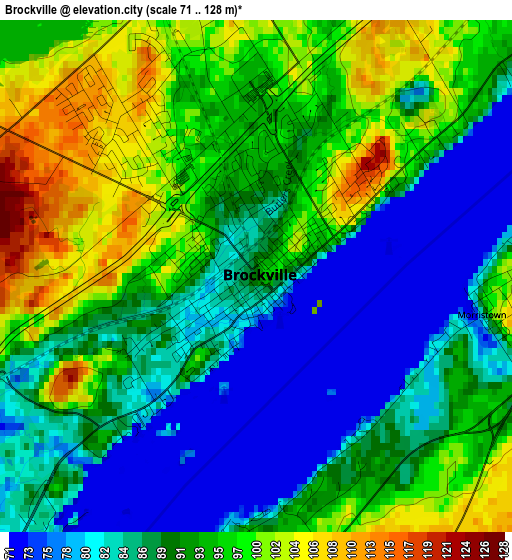
Below is the Elevation map of Brockville, which displays elevation range with different colors. Scale of the first map is from 71 to 128 m (233 to 420 ft) with average elevation of 90.8 meters (=298 ft) [note 1]
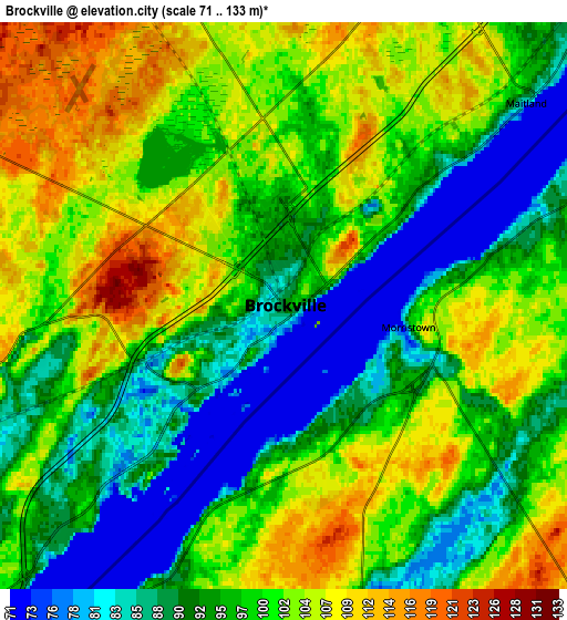
These maps also provides idea of topography and contour of this city, they are displayed at different zoom levels. More info about maps, scale and edge coordinates you can find below images.
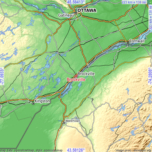
| \ | Map #1 | Map #2 | Topo.Map |
| Scale [m] | 71..128 m | 71..133 m | × |
| Scale [ft] | 233..420 ft | 233..436 ft | × |
| Average | 90.8 m = 298 ft | 97.6 m = 320 ft | × |
| Width | 6.96 km = 4.3 mi | 13.92 km = 8.6 mi | 222.7 km = 138.4 mi |
| Height | 6.96 km = 4.3 mi | 13.92 km = 8.6 mi | 222.7 km = 138.4 mi |
| ↑Max Latitude | 44.622606° | 44.653876° | 45.58413° |
| Latitude at center | 44.59132° | 44.59132° | 44.59132° |
| ↓Min Latitude | 44.560017° | 44.528697° | 43.58126° |
| ← Min Longitude | -75.730995° | -75.774941° | -77.0933° |
| Longitude center | -75.68705° | -75.68705° | -75.68705° |
| →Max Longitude | -75.643105° | -75.599159° | -74.2808° |
Nearby cities:
Cities around Brockville sort by population:
• Kingston elevation 83 m
74.8 km,  237°
237°
• Carleton Place 144 m
70.4 km,  328°
328°
• Smiths Falls 131 m
43.8 km,  322°
322°
• Perth 134 m
56.1 km,  307°
307°
• Gananoque 84 m
47.6 km,  232°
232°
• Prescott 90 m
19.4 km,  44°
44°
• Russell 72 m
77.5 km,  19°
19°
• Richmond 90 m
66.8 km,  350°
350°
• Morrisburg 77 m
52.6 km,  49°
49°
• Osgoode 102 m
62.4 km,  6°
6°
• Winchester 75 m
60.8 km,  25°
25°
• Metcalfe 89 m
73.5 km, 13°
Multilingual:
 En español:
Brockville elevación 93 m.
 En France:
Brockville élévation 93 m.
 Auf Deutsch:
Brockville höhe über dem Meeresspiegel ist 93 m.

Sources and notes:
- [note 1] Map square and city borders are not equal. Map elevation data is calculated only from area inside that square.
- [src 1] Elevation data from geonames database provided with same terms of usage.
- [src 2] The elevation map of Brockville is generated using elevation data from NASA's 3 arcsec (90m) resolution SRTM data.
- [src 3] Base (background) map © OpenStreetMap contributors tiles are generated by Geofabrik and OpenTopoMap.
Copyright & License:
This Brockville Elevation Map is licensed under CC BY-SA. You may reuse any part from this page, if you give a proper credit by linking to this URL:
 More info on terms of use page.