Russell elevation
Russell (Ontario), Canada elevation is 72 meters and Russell elevation in feet is 236 ft above sea level [src 1]. Russell is a populated place (feature code) with elevation that is 186 meters (610 ft) smaller than average city elevation in Canada.
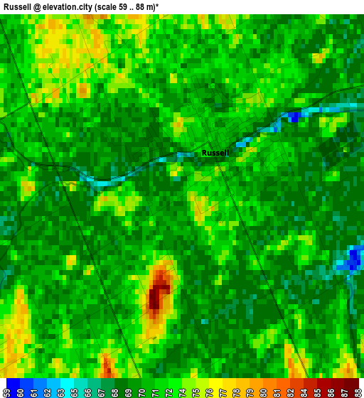
Below is the Elevation map of Russell, which displays elevation range with different colors. Scale of the first map is from 59 to 88 m (194 to 289 ft) with average elevation of 71.1 meters (=233 ft) [note 1]
These maps also provides idea of topography and contour of this city, they are displayed at different zoom levels. More info about maps, scale and edge coordinates you can find below images.
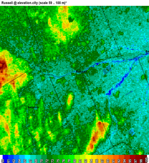
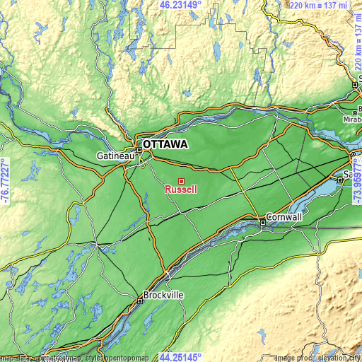
| \ | Map #1 | Map #2 | Topo.Map |
| Scale [m] | 59..88 m | 59..100 m | × |
| Scale [ft] | 194..289 ft | 194..328 ft | × |
| Average | 71.1 m = 233 ft | 72.9 m = 239 ft | × |
| Width | 6.88 km = 4.3 mi | 13.76 km = 8.6 mi | 220.2 km = 136.8 mi |
| Height | 6.88 km = 4.3 mi | 13.76 km = 8.6 mi | 220.1 km = 136.8 mi |
| ↑Max Latitude | 45.28103° | 45.311942° | 46.23149° |
| Latitude at center | 45.2501° | 45.2501° | 45.2501° |
| ↓Min Latitude | 45.219153° | 45.18819° | 44.25145° |
| ← Min Longitude | -75.409965° | -75.453911° | -76.77227° |
| Longitude center | -75.36602° | -75.36602° | -75.36602° |
| →Max Longitude | -75.322075° | -75.278129° | -73.95977° |
Nearby cities:
Cities around Russell sort by population:
• Ottawa elevation 71 m
31.5 km,  304°
304°
• Nepean 102 m
31.4 km,  291°
291°
• Fallingbrook 78 m
26.7 km,  339°
339°
• Clarence-Rockland 55 m
33.9 km,  9°
9°
• Vanier 57 m
31.5 km,  312°
312°
• Queenswood Heights 86 m
26.9 km, 336°
• Casselman 64 m
23.4 km,  71°
71°
• Osgoode 102 m
21.4 km,  238°
238°
• Winchester 75 m
18.6 km,  175°
175°
• Limoges 68 m
13 km,  44°
44°
• Metcalfe 89 m
8 km,  256°
256°
• Bourget 61 m
26.5 km, 39°
Multilingual:
 En español:
Russell elevación 72 m.
 En France:
Russell élévation 72 m.


Sources and notes:
- [note 1] Map square and city borders are not equal. Map elevation data is calculated only from area inside that square.
- [src 1] Elevation data from geonames database provided with same terms of usage.
- [src 2] The elevation map of Russell is generated using elevation data from NASA's 3 arcsec (90m) resolution SRTM data.
- [src 3] Base (background) map © OpenStreetMap contributors tiles are generated by Geofabrik and OpenTopoMap.
Copyright & License:
This Russell Elevation Map is licensed under CC BY-SA. You may reuse any part from this page, if you give a proper credit by linking to this URL:
 More info on terms of use page.